Hallein geodata
Hallein (Salzburg) is a seat of a third-order administrative division; located in Austria in Europe/Vienna (GMT+2) time zone. With population of 7,208 people, there are 128 cities with bigger population in this country. Compared to other cities in Austria, 52.8% of cities are located further ↓South; 81.4% of cities are located further →East and 50.6% of cities have higher elevation than Hallein. Note1


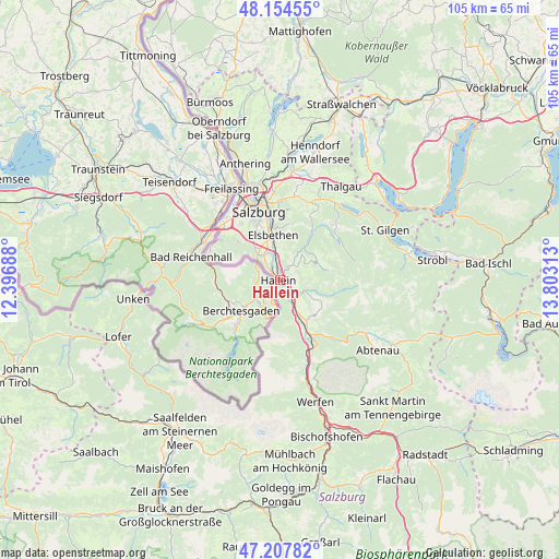
Hallein GPS coordinates[2]
47° 40' 59.988" North, 13° 6' 0" East
| Map corner | latitude | longitude |
|---|---|---|
| Upper-left | 48.15455°, | 12.39688° |
| Center: | 47.68333°, | 13.1° |
| Lower-right: | 47.20782°, | 13.80313° |
| Map W x H: | 105.3×105.3 km | = 65.4×65.4mi |
| max Lat: | 48.98333° ⇑47.2% North |
| Hallein: | 47.68333° |
| min Lat: | ⇓52.8% South 46.48841° |
| min Long | Hallein | max Long |
| 9.57802° | 13.1° | 17.1° |
| W 18.6%⇐ | ⇒81.4% E |
Elevation
Elevation of Hallein is 447 m = 1467 ft, and this is 58.5 m = 192 ft below average elevation for this country.
| Max E: |
2140 m = 7021 ft | 50.6% |
| Avg. | 505.5 m = 1658 ft | |
| Hallein | 447 m = 1467 ft | |
Min E: |
118 m = 387 ft | 49.4% |
See also: Austria elevation on elevation.city.
Geographical zone
Hallein is located in North temperate zone (between Tropic of Cancer and the Arctic Circle). Distance of this North polar circle is 2099.3 km =1304.4 mi to North.| Distance of | km | miles | from Hallein |
|---|---|---|---|
| North Pole | 4705.2 | 2923.7 | to North |
| Arctic Circle | 2099.3 | 1304.4 | to North |
| Tropic Cancer | 2696 | 1675.2 | to South |
| Equator | 5301.9 | 3294.4 | to South |


Nearby cities:
15 places around Hallein: (largest is in red/bold)
• Adnet
2.8 km =1.7 mi,  56°
56°
• Au
3.1 km =1.9 mi,  306°
306°
• Bad Dürrnberg
2.2 km =1.4 mi,  200°
200°
• Burgfried
1 km =0.6 mi,  112°
112°
• Garnei
4.5 km =2.8 mi,  149°
149°
• Jadorf
6.2 km =3.9 mi,  144°
144°
• Neualm
1.5 km =0.9 mi,  320°
320°
• Niederalm
5.8 km =3.6 mi,  330°
330°
• Oberalm
1.9 km =1.2 mi,  0°
0°
• Puch bei Hallein
3.6 km =2.2 mi,  351°
351°
• Sankt Leonhard
6.2 km =3.9 mi, 319°
• Taxach
5.2 km =3.2 mi,  336°
336°
• Vigaun
3.1 km =1.9 mi,  126°
126°
• Waidach
2.9 km =1.8 mi,  77°
77°
• Wimberg
5.4 km =3.4 mi,  45°
45°
Sources, notices
• [Note1] Compared only with cities in Austria existing in our database
• [Src1] Map data: © OpenStreetMap contributors (CC-BY-SA)
• [Src2] Other city data from geonames.org with taken over terms of usage.
• [Src3] Geographical zone / Annual Mean Temperature by Robert A. Rohde @ Wikipedia
