Himberg geodata
Himberg (Lower Austria) is a seat of a third-order administrative division; located in Austria in Europe/Vienna (GMT+2) time zone. With population of 5,331 people, there are 178 cities with bigger population in this country. Compared to other cities in Austria, 71.7% of cities are located further ↓South; 92.2% of cities are located further ←West and 96.3% of cities have higher elevation than Himberg. Note1
Administrative division(s):
- Level 1: Lower Austria
- Level 2: Politischer Bezirk Bruck an der Leitha
- Level 3: Himberg


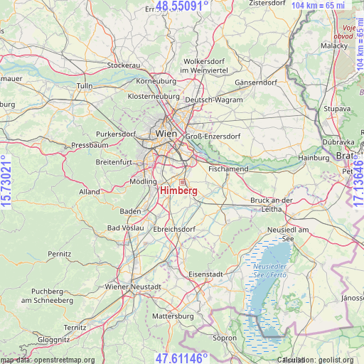
Himberg GPS coordinates[2]
48° 4' 59.988" North, 16° 25' 59.988" East
| Map corner | latitude | longitude |
|---|---|---|
| Upper-left | 48.55091°, | 15.73021° |
| Center: | 48.08333°, | 16.43333° |
| Lower-right: | 47.61146°, | 17.13646° |
| Map W x H: | 104.5×104.5 km | = 64.9×64.9mi |
| max Lat: | 48.98333° ⇑28.3% North |
| Himberg: | 48.08333° |
| min Lat: | ⇓71.7% South 46.48841° |
| min Long | Himberg | max Long |
| 9.57802° | 16.43333° | 17.1° |
| W 92.2%⇐ | ⇒7.8% E |
Elevation
Elevation of Himberg is 168 m = 551 ft, and this is 337.5 m = 1107 ft below average elevation for this country.
| Max E: |
2140 m = 7021 ft | 96.3% |
| Avg. | 505.5 m = 1658 ft | |
| Himberg | 168 m = 551 ft | |
Min E: |
118 m = 387 ft | 3.7% |
See also: Austria elevation on elevation.city.
Geographical zone
Himberg is located in North temperate zone (between Tropic of Cancer and the Arctic Circle). Distance of this North polar circle is 2054.8 km =1276.8 mi to North.| Distance of | km | miles | from Himberg |
|---|---|---|---|
| North Pole | 4660.7 | 2896 | to North |
| Arctic Circle | 2054.8 | 1276.8 | to North |
| Tropic Cancer | 2740.4 | 1702.8 | to South |
| Equator | 5346.4 | 3322.1 | to South |


Nearby cities:
15 places around Himberg: (largest is in red/bold)
• Achau
3.5 km =2.2 mi,  264°
264°
• Biedermannsdorf
6.5 km =4 mi,  270°
270°
• Hennersdorf
6.1 km =3.8 mi,  301°
301°
• Kledering
5.5 km =3.4 mi,  2°
2°
• Lanzendorf
3.1 km =1.9 mi,  15°
15°
• Laxenburg
6 km =3.7 mi,  253°
253°
• Leopoldsdorf
4.8 km =3 mi,  318°
318°
• Maria Lanzendorf
2 km =1.2 mi,  330°
330°
• Münchendorf
6.7 km =4.2 mi,  213°
213°
• Pellendorf
2.2 km =1.4 mi,  42°
42°
• Rannersdorf
5.4 km =3.4 mi, 24°
• Rauchenwarth
7 km =4.3 mi,  90°
90°
• Schwechat
6.1 km =3.8 mi, 24°
• Velm
5.6 km =3.5 mi,  180°
180°
• Zwölfaxing
3.7 km =2.3 mi, 36°
Sources, notices
• [Note1] Compared only with cities in Austria existing in our database
• [Src1] Map data: © OpenStreetMap contributors (CC-BY-SA)
• [Src2] Other city data from geonames.org with taken over terms of usage.
• [Src3] Geographical zone / Annual Mean Temperature by Robert A. Rohde @ Wikipedia
