Laxenburg geodata
Laxenburg (Lower Austria) is a seat of a third-order administrative division; located in Austria in Europe/Vienna (GMT+2) time zone. With population of 2,828 people, there are 406 cities with bigger population in this country. Compared to other cities in Austria, 70.6% of cities are located further ↓South; 90.1% of cities are located further ←West and 95.1% of cities have higher elevation than Laxenburg. Note1
Administrative division(s):
- Level 1: Lower Austria
- Level 2: Politischer Bezirk Mödling
- Level 3: Laxenburg


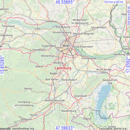
Laxenburg GPS coordinates[2]
48° 4' 5.988" North, 16° 21' 21.852" East
| Map corner | latitude | longitude |
|---|---|---|
| Upper-left | 48.53605°, | 15.65295° |
| Center: | 48.06833°, | 16.35607° |
| Lower-right: | 47.59633°, | 17.0592° |
| Map W x H: | 104.5×104.5 km | = 64.9×64.9mi |
| max Lat: | 48.98333° ⇑29.4% North |
| Laxenburg: | 48.06833° |
| min Lat: | ⇓70.6% South 46.48841° |
| min Long | Laxenburg | max Long |
| 9.57802° | 16.35607° | 17.1° |
| W 90.1%⇐ | ⇒9.9% E |
Elevation
Elevation of Laxenburg is 179 m = 587 ft, and this is 326.5 m = 1071 ft below average elevation for this country.
| Max E: |
2140 m = 7021 ft | 95.1% |
| Avg. | 505.5 m = 1658 ft | |
| Laxenburg | 179 m = 587 ft | |
Min E: |
118 m = 387 ft | 4.9% |
See also: Austria elevation on elevation.city.
Geographical zone
Laxenburg is located in North temperate zone (between Tropic of Cancer and the Arctic Circle). Distance of this North polar circle is 2056.5 km =1277.8 mi to North.| Distance of | km | miles | from Laxenburg |
|---|---|---|---|
| North Pole | 4662.4 | 2897.1 | to North |
| Arctic Circle | 2056.5 | 1277.8 | to North |
| Tropic Cancer | 2738.8 | 1701.8 | to South |
| Equator | 5344.7 | 3321 | to South |


Nearby cities:
15 places around Laxenburg: (largest is in red/bold)
• Achau
2.6 km =1.6 mi,  59°
59°
• Biedermannsdorf
1.9 km =1.2 mi,  335°
335°
• Gumpoldskirchen
6.4 km =4 mi,  246°
246°
• Guntramsdorf
3.9 km =2.4 mi,  232°
232°
• Hennersdorf
4.9 km =3 mi,  6°
6°
• Himberg
6 km =3.7 mi,  73°
73°
• Leopoldsdorf
5.9 km =3.7 mi,  26°
26°
• Maria Enzersdorf
6.4 km =4 mi,  303°
303°
• Maria Lanzendorf
5.9 km =3.7 mi,  54°
54°
• Mödling
5.3 km =3.3 mi,  291°
291°
• Möllersdorf
6.1 km =3.8 mi,  218°
218°
• Münchendorf
4.4 km =2.7 mi,  152°
152°
• Neu-Guntramsdorf
3 km =1.9 mi,  261°
261°
• Vösendorf
6 km =3.7 mi,  348°
348°
• Wiener Neudorf
3.5 km =2.2 mi, 297°
Sources, notices
• [Note1] Compared only with cities in Austria existing in our database
• [Src1] Map data: © OpenStreetMap contributors (CC-BY-SA)
• [Src2] Other city data from geonames.org with taken over terms of usage.
• [Src3] Geographical zone / Annual Mean Temperature by Robert A. Rohde @ Wikipedia
