Hernstein geodata
Hernstein (Lower Austria) is a seat of a third-order administrative division; located in Austria in Europe/Vienna (GMT+2) time zone. With population of 473 people, there are 2538 cities with bigger population in this country. Compared to other cities in Austria, 60.8% of cities are located further ↓South; 83.3% of cities are located further ←West and 52.6% of cities have higher elevation than Hernstein. Note1
Administrative division(s):
- Level 1: Lower Austria
- Level 2: Politischer Bezirk Baden
- Level 3: Hernstein


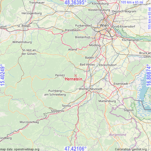
Hernstein GPS coordinates[2]
47° 53' 40.74" North, 16° 6' 20.196" East
| Map corner | latitude | longitude |
|---|---|---|
| Upper-left | 48.36395°, | 15.40249° |
| Center: | 47.89465°, | 16.10561° |
| Lower-right: | 47.42106°, | 16.80874° |
| Map W x H: | 104.8×104.8 km | = 65.1×65.1mi |
| max Lat: | 48.98333° ⇑39.2% North |
| Hernstein: | 47.89465° |
| min Lat: | ⇓60.8% South 46.48841° |
| min Long | Hernstein | max Long |
| 9.57802° | 16.10561° | 17.1° |
| W 83.3%⇐ | ⇒16.7% E |
Elevation
Elevation of Hernstein is 436 m = 1430 ft, and this is 69.5 m = 228 ft below average elevation for this country.
| Max E: |
2140 m = 7021 ft | 52.6% |
| Avg. | 505.5 m = 1658 ft | |
| Hernstein | 436 m = 1430 ft | |
Min E: |
118 m = 387 ft | 47.4% |
See also: Austria elevation on elevation.city.
Geographical zone
Hernstein is located in North temperate zone (between Tropic of Cancer and the Arctic Circle). Distance of this North polar circle is 2075.8 km =1289.8 mi to North.| Distance of | km | miles | from Hernstein |
|---|---|---|---|
| North Pole | 4681.7 | 2909.1 | to North |
| Arctic Circle | 2075.8 | 1289.8 | to North |
| Tropic Cancer | 2719.5 | 1689.8 | to South |
| Equator | 5325.4 | 3309 | to South |


Nearby cities:
15 places around Hernstein: (largest is in red/bold)
• Bad Fischau
8.4 km =5.2 mi,  146°
146°
• Berndorf
5.7 km =3.5 mi,  3°
3°
• Brunn an der Schneebergbahn
8.8 km =5.5 mi, 153°
• Dreistetten
4.4 km =2.7 mi,  185°
185°
• Großau
8.2 km =5.1 mi,  34°
34°
• Hirtenberg
6.8 km =4.2 mi,  53°
53°
• Markt Piesting
2.8 km =1.7 mi, 148°
• Matzendorf
8.1 km =5 mi,  92°
92°
• Muthmannsdorf
6.3 km =3.9 mi,  177°
177°
• Oberpiesting
2.1 km =1.3 mi, 193°
• Pottenstein
7.1 km =4.4 mi,  353°
353°
• Steinabrückl
7.7 km =4.8 mi,  110°
110°
• Stollhof
7.6 km =4.7 mi,  200°
200°
• Waldegg
5 km =3.1 mi,  234°
234°
• Wöllersdorf
5.9 km =3.7 mi,  123°
123°
Sources, notices
• [Note1] Compared only with cities in Austria existing in our database
• [Src1] Map data: © OpenStreetMap contributors (CC-BY-SA)
• [Src2] Other city data from geonames.org with taken over terms of usage.
• [Src3] Geographical zone / Annual Mean Temperature by Robert A. Rohde @ Wikipedia
