Waldegg geodata
Waldegg (Lower Austria) is a seat of a third-order administrative division; located in Austria in Europe/Vienna (GMT+2) time zone. With population of 408 people, there are 2609 cities with bigger population in this country. Compared to other cities in Austria, 59.6% of cities are located further ↓South; 81.8% of cities are located further ←West and 61.5% of cities have higher elevation than Waldegg. Note1
Administrative division(s):
- Level 1: Lower Austria
- Level 2: Politischer Bezirk Wiener Neustadt
- Level 3: Waldegg


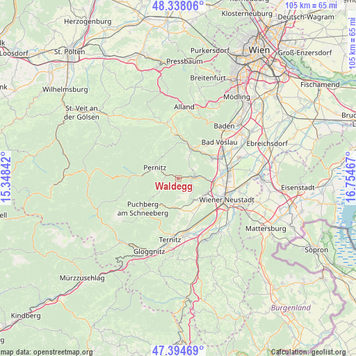
Waldegg GPS coordinates[2]
47° 52' 6.672" North, 16° 3' 5.544" East
| Map corner | latitude | longitude |
|---|---|---|
| Upper-left | 48.33806°, | 15.34842° |
| Center: | 47.86852°, | 16.05154° |
| Lower-right: | 47.39469°, | 16.75467° |
| Map W x H: | 104.9×104.9 km | = 65.2×65.2mi |
| max Lat: | 48.98333° ⇑40.4% North |
| Waldegg: | 47.86852° |
| min Lat: | ⇓59.6% South 46.48841° |
| min Long | Waldegg | max Long |
| 9.57802° | 16.05154° | 17.1° |
| W 81.8%⇐ | ⇒18.2% E |
Elevation
Elevation of Waldegg is 373 m = 1224 ft, and this is 132.5 m = 435 ft below average elevation for this country.
| Max E: |
2140 m = 7021 ft | 61.5% |
| Avg. | 505.5 m = 1658 ft | |
| Waldegg | 373 m = 1224 ft | |
Min E: |
118 m = 387 ft | 38.5% |
See also: Austria elevation on elevation.city.
Geographical zone
Waldegg is located in North temperate zone (between Tropic of Cancer and the Arctic Circle). Distance of this North polar circle is 2078.7 km =1291.6 mi to North.| Distance of | km | miles | from Waldegg |
|---|---|---|---|
| North Pole | 4684.6 | 2910.9 | to North |
| Arctic Circle | 2078.7 | 1291.6 | to North |
| Tropic Cancer | 2716.6 | 1688 | to South |
| Equator | 5322.5 | 3307.2 | to South |


Nearby cities:
15 places around Waldegg: (largest is in red/bold)
• Dreistetten
3.9 km =2.4 mi,  111°
111°
• Grünbach am Schneeberg
9.2 km =5.7 mi,  211°
211°
• Hernstein
5 km =3.1 mi,  54°
54°
• Maiersdorf
5.6 km =3.5 mi,  176°
176°
• Markt Piesting
5.5 km =3.4 mi,  84°
84°
• Miesenbach
6 km =3.7 mi,  238°
238°
• Muthmannsdorf
5.5 km =3.4 mi,  127°
127°
• Neusiedl
6.9 km =4.3 mi,  287°
287°
• Oberpiesting
3.6 km =2.2 mi, 76°
• Pernitz
7.5 km =4.7 mi,  295°
295°
• Stollhof
4.4 km =2.7 mi,  161°
161°
• Waidmannsfeld
5.3 km =3.3 mi,  272°
272°
• Willendorf am Steinfelde
8.8 km =5.5 mi, 177°
• Winzendorf
7.8 km =4.8 mi,  144°
144°
• Wöllersdorf
8.9 km =5.5 mi,  92°
92°
Sources, notices
• [Note1] Compared only with cities in Austria existing in our database
• [Src1] Map data: © OpenStreetMap contributors (CC-BY-SA)
• [Src2] Other city data from geonames.org with taken over terms of usage.
• [Src3] Geographical zone / Annual Mean Temperature by Robert A. Rohde @ Wikipedia
