Pottenstein geodata
Pottenstein (Lower Austria) is a seat of a third-order administrative division; located in Austria in Europe/Vienna (GMT+2) time zone. With population of 2,495 people, there are 476 cities with bigger population in this country. Compared to other cities in Austria, 63.9% of cities are located further ↓South; 82.7% of cities are located further ←West and 70.8% of cities have higher elevation than Pottenstein. Note1
Administrative division(s):
- Level 1: Lower Austria
- Level 2: Politischer Bezirk Baden
- Level 3: Pottenstein


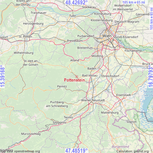
Pottenstein GPS coordinates[2]
47° 57' 29.52" North, 16° 5' 41.28" East
| Map corner | latitude | longitude |
|---|---|---|
| Upper-left | 48.42692°, | 15.39168° |
| Center: | 47.9582°, | 16.0948° |
| Lower-right: | 47.48519°, | 16.79793° |
| Map W x H: | 104.7×104.7 km | = 65.1×65.1mi |
| max Lat: | 48.98333° ⇑36.1% North |
| Pottenstein: | 47.9582° |
| min Lat: | ⇓63.9% South 46.48841° |
| min Long | Pottenstein | max Long |
| 9.57802° | 16.0948° | 17.1° |
| W 82.7%⇐ | ⇒17.3% E |
Elevation
Elevation of Pottenstein is 324 m = 1063 ft, and this is 181.5 m = 595 ft below average elevation for this country.
| Max E: |
2140 m = 7021 ft | 70.8% |
| Avg. | 505.5 m = 1658 ft | |
| Pottenstein | 324 m = 1063 ft | |
Min E: |
118 m = 387 ft | 29.2% |
See also: Austria elevation on elevation.city.
Geographical zone
Pottenstein is located in North temperate zone (between Tropic of Cancer and the Arctic Circle). Distance of this North polar circle is 2068.7 km =1285.4 mi to North.| Distance of | km | miles | from Pottenstein |
|---|---|---|---|
| North Pole | 4674.6 | 2904.7 | to North |
| Arctic Circle | 2068.7 | 1285.4 | to North |
| Tropic Cancer | 2726.5 | 1694.2 | to South |
| Equator | 5332.5 | 3313.5 | to South |


Nearby cities:
15 places around Pottenstein: (largest is in red/bold)
• Altenmarkt an der Triesting
9.7 km =6 mi,  311°
311°
• Bad Vöslau
8.9 km =5.5 mi,  84°
84°
• Berndorf
1.8 km =1.1 mi,  141°
141°
• Furth an der Triesting
9.2 km =5.7 mi,  280°
280°
• Gainfarn
7.4 km =4.6 mi,  86°
86°
• Großau
5.5 km =3.4 mi, 92°
• Hernstein
7.1 km =4.4 mi,  173°
173°
• Hirtenberg
7 km =4.3 mi,  115°
115°
• Kottingbrunn
9.9 km =6.2 mi, 94°
• Leobersdorf
9.7 km =6 mi,  110°
110°
• Markt Piesting
9.7 km =6 mi, 166°
• Neuhaus
5.5 km =3.4 mi,  318°
318°
• Oberpiesting
9.2 km =5.7 mi,  178°
178°
• Sooss
9.6 km =6 mi,  72°
72°
• Weissenbach an der Triesting
4.9 km =3 mi,  302°
302°
Sources, notices
• [Note1] Compared only with cities in Austria existing in our database
• [Src1] Map data: © OpenStreetMap contributors (CC-BY-SA)
• [Src2] Other city data from geonames.org with taken over terms of usage.
• [Src3] Geographical zone / Annual Mean Temperature by Robert A. Rohde @ Wikipedia
