Hernals geodata
Hernals (Vienna) is a section of populated place; located in Austria in Europe/Vienna (GMT+2) time zone. With population of 57,546 people, there are 13 cities with bigger population in this country. Compared to other cities in Austria, 81.7% of cities are located further ↓South; 87.9% of cities are located further ←West and 67.9% of cities have higher elevation than Hernals. Note1


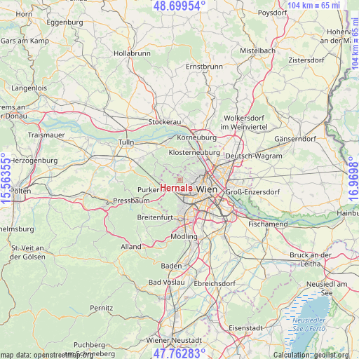
Hernals GPS coordinates[2]
48° 13' 59.988" North, 16° 16' 0.012" East
| Map corner | latitude | longitude |
|---|---|---|
| Upper-left | 48.69954°, | 15.56355° |
| Center: | 48.23333°, | 16.26667° |
| Lower-right: | 47.76283°, | 16.9698° |
| Map W x H: | 104.2×104.1 km | = 64.7×64.7mi |
| max Lat: | 48.98333° ⇑18.3% North |
| Hernals: | 48.23333° |
| min Lat: | ⇓81.7% South 46.48841° |
| min Long | Hernals | max Long |
| 9.57802° | 16.26667° | 17.1° |
| W 87.9%⇐ | ⇒12.1% E |
Elevation
Elevation of Hernals is 339 m = 1112 ft, and this is 166.5 m = 546 ft below average elevation for this country.
| Max E: |
2140 m = 7021 ft | 67.9% |
| Avg. | 505.5 m = 1658 ft | |
| Hernals | 339 m = 1112 ft | |
Min E: |
118 m = 387 ft | 32.1% |
See also: Hernals elevation on elevation.city.
Geographical zone
Hernals is located in North temperate zone (between Tropic of Cancer and the Arctic Circle). Distance of this North polar circle is 2038.1 km =1266.4 mi to North.| Distance of | km | miles | from Hernals |
|---|---|---|---|
| North Pole | 4644 | 2885.6 | to North |
| Arctic Circle | 2038.1 | 1266.4 | to North |
| Tropic Cancer | 2757.1 | 1713.2 | to South |
| Equator | 5363 | 3332.4 | to South |


Nearby cities:
15 places around Hernals: (largest is in red/bold)
• Gablitz
8.3 km =5.2 mi,  266°
266°
• Gugging
9.1 km =5.7 mi,  351°
351°
• Hietzing
5.7 km =3.5 mi,  157°
157°
• Hintersdorf
8.3 km =5.2 mi,  333°
333°
• Innere Stadt
8.2 km =5.1 mi,  109°
109°
• Kierling
8.6 km =5.3 mi,  4°
4°
• Kirchbach
7.8 km =4.8 mi,  318°
318°
• Klosterneuburg
9.1 km =5.7 mi,  28°
28°
• Mauerbach
7.4 km =4.6 mi,  280°
280°
• Meidling
8.9 km =5.5 mi,  146°
146°
• Ottakring
3.1 km =1.9 mi,  126°
126°
• Purkersdorf
7.3 km =4.5 mi,  247°
247°
• Vienna
8.3 km =5.2 mi, 109°
• Weidling
7.1 km =4.4 mi, 25°
• Weidlingbach
3.9 km =2.4 mi,  341°
341°
Sources, notices
• [Note1] Compared only with cities in Austria existing in our database
• [Src1] Map data: © OpenStreetMap contributors (CC-BY-SA)
• [Src2] Other city data from geonames.org with taken over terms of usage.
• [Src3] Geographical zone / Annual Mean Temperature by Robert A. Rohde @ Wikipedia
