Hermagor geodata
Hermagor (Carinthia) is a seat of a second-order administrative division; located in Austria in Europe/Vienna (GMT+2) time zone. With population of 1,535 people, there are 821 cities with bigger population in this country. Compared to other cities in Austria, 97.3% of cities are located further ↑North; 76.9% of cities are located further →East and 71.4% of cities have lower elevation than Hermagor. Note1
Administrative division(s):
- Level 1: Carinthia
- Level 2: Politischer Bezirk Hermagor
- Level 3: Hermagor-Pressegger See


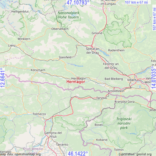
Hermagor GPS coordinates[2]
46° 37' 37.992" North, 13° 22' 1.992" East
| Map corner | latitude | longitude |
|---|---|---|
| Upper-left | 47.10793°, | 12.6641° |
| Center: | 46.62722°, | 13.36722° |
| Lower-right: | 46.1422°, | 14.07035° |
| Map W x H: | 107.4×107.4 km | = 66.7×66.7mi |
| max Lat: | 48.98333° ⇑97.3% North |
| Hermagor: | 46.62722° |
| min Lat: | ⇓2.7% South 46.48841° |
| min Long | Hermagor | max Long |
| 9.57802° | 13.36722° | 17.1° |
| W 23.1%⇐ | ⇒76.9% E |
Elevation
Elevation of Hermagor is 605 m = 1985 ft, and this is 99.5 m = 326 ft above average elevation for this country.
| Max E: |
2140 m = 7021 ft | 28.6% |
| Hermagor | 605 m 1985 ft | |
| Avg. | 505.5 m = 1658 ft | |
Min E: |
118 m = 387 ft | 71.4% |
See also: Austria elevation on elevation.city.
Geographical zone
Hermagor is located in North temperate zone (between Tropic of Cancer and the Arctic Circle). Distance of this North polar circle is 2216.7 km =1377.4 mi to North.| Distance of | km | miles | from Hermagor |
|---|---|---|---|
| North Pole | 4822.6 | 2996.6 | to North |
| Arctic Circle | 2216.7 | 1377.4 | to North |
| Tropic Cancer | 2578.5 | 1602.2 | to South |
| Equator | 5184.5 | 3221.5 | to South |


Nearby cities:
15 places around Hermagor: (largest is in red/bold)
• Baldramsdorf
20.4 km =12.7 mi,  18°
18°
• Berg im Drautal
22.3 km =13.9 mi,  307°
307°
• Bleiberg-Kreuth
20.5 km =12.7 mi,  88°
88°
• Dellach
22.3 km =13.9 mi,  279°
279°
• Feistritz an der Gail
19.1 km =11.9 mi,  106°
106°
• Grafendorf
19.7 km =12.2 mi, 280°
• Greifenburg
19.8 km =12.3 mi, 313°
• Kirchbach
14 km =8.7 mi, 276°
• Lind
15.8 km =9.8 mi,  358°
358°
• Nötsch
19.7 km =12.2 mi,  104°
104°
• Nötsch bei Bleiberg
21.4 km =13.3 mi, 90°
• Spittal an der Drau
21.7 km =13.5 mi,  27°
27°
• Steinfeld
17.1 km =10.6 mi,  328°
328°
• Stockenboi
16.2 km =10.1 mi,  47°
47°
• Weissbriach
10.8 km =6.7 mi, 305°
Sources, notices
• [Note1] Compared only with cities in Austria existing in our database
• [Src1] Map data: © OpenStreetMap contributors (CC-BY-SA)
• [Src2] Other city data from geonames.org with taken over terms of usage.
• [Src3] Geographical zone / Annual Mean Temperature by Robert A. Rohde @ Wikipedia
