Greifenburg geodata
Greifenburg (Carinthia) is a seat of a third-order administrative division; located in Austria in Europe/Vienna (GMT+2) time zone. With population of 1,012 people, there are 1271 cities with bigger population in this country. Compared to other cities in Austria, 93.5% of cities are located further ↑North; 79.6% of cities are located further →East and 74.3% of cities have lower elevation than Greifenburg. Note1
Administrative division(s):
- Level 1: Carinthia
- Level 2: Politischer Bezirk Spittal an der Drau
- Level 3: Greifenburg


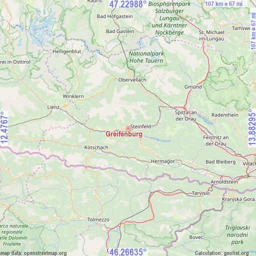
Greifenburg GPS coordinates[2]
46° 45' 0.972" North, 13° 10' 47.352" East
| Map corner | latitude | longitude |
|---|---|---|
| Upper-left | 47.22988°, | 12.4767° |
| Center: | 46.75027°, | 13.17982° |
| Lower-right: | 46.26635°, | 13.88295° |
| Map W x H: | 107.1×107.1 km | = 66.5×66.5mi |
| max Lat: | 48.98333° ⇑93.5% North |
| Greifenburg: | 46.75027° |
| min Lat: | ⇓6.5% South 46.48841° |
| min Long | Greifenburg | max Long |
| 9.57802° | 13.17982° | 17.1° |
| W 20.4%⇐ | ⇒79.6% E |
Elevation
Elevation of Greifenburg is 640 m = 2100 ft, and this is 134.5 m = 441 ft above average elevation for this country.
| Max E: |
2140 m = 7021 ft | 25.7% |
| Greifenburg | 640 m 2100 ft | |
| Avg. | 505.5 m = 1658 ft | |
Min E: |
118 m = 387 ft | 74.3% |
See also: Austria elevation on elevation.city.
Geographical zone
Greifenburg is located in North temperate zone (between Tropic of Cancer and the Arctic Circle). Distance of this North polar circle is 2203 km =1368.9 mi to North.| Distance of | km | miles | from Greifenburg |
|---|---|---|---|
| North Pole | 4808.9 | 2988.1 | to North |
| Arctic Circle | 2203 | 1368.9 | to North |
| Tropic Cancer | 2592.2 | 1610.7 | to South |
| Equator | 5198.1 | 3229.9 | to South |


Nearby cities:
15 places around Greifenburg: (largest is in red/bold)
• Berg
3.7 km =2.3 mi,  267°
267°
• Berg im Drautal
3.4 km =2.1 mi, 267°
• Dellach
12.5 km =7.8 mi,  217°
217°
• Dellach im Drautal
7.9 km =4.9 mi,  259°
259°
• Grafendorf
11.4 km =7.1 mi,  206°
206°
• Irschen
11.8 km =7.3 mi, 273°
• Kirchbach
12.1 km =7.5 mi,  178°
178°
• Kötschach
15.2 km =9.4 mi,  239°
239°
• Lind
13.9 km =8.6 mi,  81°
81°
• Mauthen
16.7 km =10.4 mi, 235°
• Möllbrücke
17.5 km =10.9 mi,  56°
56°
• Oberdrauburg
16 km =9.9 mi, 267°
• Sachsenburg
16 km =9.9 mi, 56°
• Steinfeld
5.4 km =3.4 mi, 80°
• Weissbriach
9.2 km =5.7 mi,  142°
142°
Sources, notices
• [Note1] Compared only with cities in Austria existing in our database
• [Src1] Map data: © OpenStreetMap contributors (CC-BY-SA)
• [Src2] Other city data from geonames.org with taken over terms of usage.
• [Src3] Geographical zone / Annual Mean Temperature by Robert A. Rohde @ Wikipedia
