Grafendorf geodata
Grafendorf (Carinthia) is a populated place; located in Austria in Europe/Vienna (GMT+2) time zone. With population of 515 people, there are 2448 cities with bigger population in this country. Compared to other cities in Austria, 96.5% of cities are located further ↑North; 81.1% of cities are located further →East and 77.6% of cities have lower elevation than Grafendorf. Note1
Administrative division(s):
- Level 1: Carinthia
- Level 2: Politischer Bezirk Hermagor
- Level 3: Kirchbach


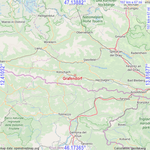
Grafendorf GPS coordinates[2]
46° 39' 30.204" North, 13° 6' 49.104" East
| Map corner | latitude | longitude |
|---|---|---|
| Upper-left | 47.13882°, | 12.41052° |
| Center: | 46.65839°, | 13.11364° |
| Lower-right: | 46.17365°, | 13.81677° |
| Map W x H: | 107.3×107.3 km | = 66.7×66.7mi |
| max Lat: | 48.98333° ⇑96.5% North |
| Grafendorf: | 46.65839° |
| min Lat: | ⇓3.5% South 46.48841° |
| min Long | Grafendorf | max Long |
| 9.57802° | 13.11364° | 17.1° |
| W 18.9%⇐ | ⇒81.1% E |
Elevation
Elevation of Grafendorf is 682 m = 2238 ft, and this is 176.5 m = 579 ft above average elevation for this country.
| Max E: |
2140 m = 7021 ft | 22.4% |
| Grafendorf | 682 m 2238 ft | |
| Avg. | 505.5 m = 1658 ft | |
Min E: |
118 m = 387 ft | 77.6% |
See also: Austria elevation on elevation.city.
Geographical zone
Grafendorf is located in North temperate zone (between Tropic of Cancer and the Arctic Circle). Distance of this North polar circle is 2213.2 km =1375.2 mi to North.| Distance of | km | miles | from Grafendorf |
|---|---|---|---|
| North Pole | 4819.1 | 2994.4 | to North |
| Arctic Circle | 2213.2 | 1375.2 | to North |
| Tropic Cancer | 2582 | 1604.4 | to South |
| Equator | 5187.9 | 3223.6 | to South |


Nearby cities:
15 places around Grafendorf: (largest is in red/bold)
• Berg
10.2 km =6.3 mi,  7°
7°
• Berg im Drautal
10.2 km =6.3 mi, 9°
• Dellach
2.6 km =1.6 mi,  278°
278°
• Dellach im Drautal
9.2 km =5.7 mi,  342°
342°
• Greifenburg
11.4 km =7.1 mi,  26°
26°
• Hermagor
19.7 km =12.2 mi,  100°
100°
• Irschen
12.9 km =8 mi,  328°
328°
• Kirchbach
5.7 km =3.5 mi,  109°
109°
• Kötschach
8.5 km =5.3 mi,  287°
287°
• Lind
22.5 km =14 mi,  56°
56°
• Mauthen
8.8 km =5.5 mi, 275°
• Nikolsdorf
20.8 km =12.9 mi,  312°
312°
• Oberdrauburg
14.4 km =8.9 mi, 310°
• Steinfeld
15.2 km =9.4 mi,  43°
43°
• Weissbriach
11 km =6.8 mi,  74°
74°
Sources, notices
• [Note1] Compared only with cities in Austria existing in our database
• [Src1] Map data: © OpenStreetMap contributors (CC-BY-SA)
• [Src2] Other city data from geonames.org with taken over terms of usage.
• [Src3] Geographical zone / Annual Mean Temperature by Robert A. Rohde @ Wikipedia
