Vordersee geodata
Vordersee (Salzburg) is a populated place; located in Austria in Europe/Vienna (GMT+2) time zone. With population of 745 people, there are 1736 cities with bigger population in this country. Compared to other cities in Austria, 55.4% of cities are located further ↓South; 78.3% of cities are located further →East and 78% of cities have lower elevation than Vordersee. Note1
Administrative division(s):
- Level 1: Salzburg
- Level 2: Politischer Bezirk Salzburg-Umgebung
- Level 3: Faistenau


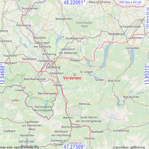
Vordersee GPS coordinates[2]
47° 45' 0" North, 13° 15' 0" East
| Map corner | latitude | longitude |
|---|---|---|
| Upper-left | 48.22061°, | 12.54688° |
| Center: | 47.75°, | 13.25° |
| Lower-right: | 47.27509°, | 13.95313° |
| Map W x H: | 105.1×105.1 km | = 65.3×65.3mi |
| max Lat: | 48.98333° ⇑44.6% North |
| Vordersee: | 47.75° |
| min Lat: | ⇓55.4% South 46.48841° |
| min Long | Vordersee | max Long |
| 9.57802° | 13.25° | 17.1° |
| W 21.7%⇐ | ⇒78.3% E |
Elevation
Elevation of Vordersee is 687 m = 2254 ft, and this is 181.5 m = 595 ft above average elevation for this country.
| Max E: |
2140 m = 7021 ft | 22% |
| Vordersee | 687 m 2254 ft | |
| Avg. | 505.5 m = 1658 ft | |
Min E: |
118 m = 387 ft | 78% |
See also: Austria elevation on elevation.city.
Geographical zone
Vordersee is located in North temperate zone (between Tropic of Cancer and the Arctic Circle). Distance of this North polar circle is 2091.9 km =1299.8 mi to North.| Distance of | km | miles | from Vordersee |
|---|---|---|---|
| North Pole | 4697.8 | 2919.1 | to North |
| Arctic Circle | 2091.9 | 1299.8 | to North |
| Tropic Cancer | 2703.4 | 1679.8 | to South |
| Equator | 5309.3 | 3299 | to South |


Nearby cities:
15 places around Vordersee: (largest is in red/bold)
• Anger
2.2 km =1.4 mi,  326°
326°
• Ebenau
7.2 km =4.5 mi,  309°
309°
• Faistenau
3.3 km =2.1 mi,  338°
338°
• Fuschl am See
6.7 km =4.2 mi,  33°
33°
• Gaißau
5.8 km =3.6 mi,  221°
221°
• Habach
10 km =6.2 mi,  318°
318°
• Hintersee
6.1 km =3.8 mi,  155°
155°
• Hof bei Salzburg
8.1 km =5 mi, 341°
• Keuschen
10 km =6.2 mi,  21°
21°
• Koppl
9.6 km =6 mi, 312°
• Krispl
6.2 km =3.9 mi,  233°
233°
• Pöllach
8.3 km =5.2 mi,  63°
63°
• Sankt Gilgen
8.9 km =5.5 mi,  78°
78°
• Vorderschroffenau
7.2 km =4.5 mi, 319°
• Wimberg
8.2 km =5.1 mi,  243°
243°
Sources, notices
• [Note1] Compared only with cities in Austria existing in our database
• [Src1] Map data: © OpenStreetMap contributors (CC-BY-SA)
• [Src2] Other city data from geonames.org with taken over terms of usage.
• [Src3] Geographical zone / Annual Mean Temperature by Robert A. Rohde @ Wikipedia
