Grünau im Almtal geodata
Grünau im Almtal (Upper Austria) is a populated place; located in Austria in Europe/Vienna (GMT+2) time zone. With population of 2,064 people, there are 591 cities with bigger population in this country. Compared to other cities in Austria, 59.1% of cities are located further ↓South; 65.9% of cities are located further →East and 59.7% of cities have lower elevation than Grünau im Almtal. Note1
Administrative division(s):
- Level 1: Upper Austria
- Level 2: Politischer Bezirk Gmunden
- Level 3: Grünau im Almtal


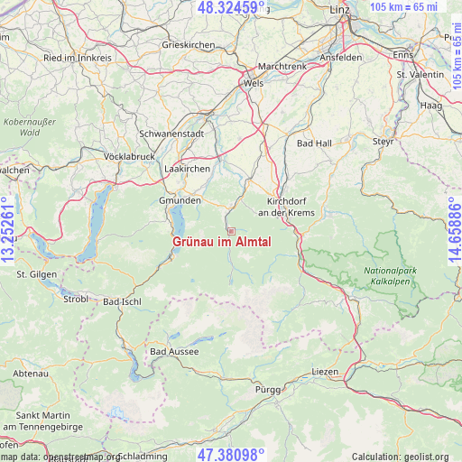
Grünau im Almtal GPS coordinates[2]
47° 51' 17.748" North, 13° 57' 20.628" East
| Map corner | latitude | longitude |
|---|---|---|
| Upper-left | 48.32459°, | 13.25261° |
| Center: | 47.85493°, | 13.95573° |
| Lower-right: | 47.38098°, | 14.65886° |
| Map W x H: | 104.9×104.9 km | = 65.2×65.2mi |
| max Lat: | 48.98333° ⇑40.9% North |
| Grünau im Almtal: | 47.85493° |
| min Lat: | ⇓59.1% South 46.48841° |
| min Long | Grünau im Almt | max Long |
| 9.57802° | 13.95573° | 17.1° |
| W 34.1%⇐ | ⇒65.9% E |
Elevation
Elevation of Grünau im Almtal is 516 m = 1693 ft, and this is 10.5 m = 34 ft above average elevation for this country.
| Max E: |
2140 m = 7021 ft | 40.3% |
| Grünau im Almtal | 516 m 1693 ft | |
| Avg. | 505.5 m = 1658 ft | |
Min E: |
118 m = 387 ft | 59.7% |
See also: Austria elevation on elevation.city.
Geographical zone
Grünau im Almtal is located in North temperate zone (between Tropic of Cancer and the Arctic Circle). Distance of this North polar circle is 2080.2 km =1292.6 mi to North.| Distance of | km | miles | from Grünau im Almtal |
|---|---|---|---|
| North Pole | 4686.1 | 2911.8 | to North |
| Arctic Circle | 2080.2 | 1292.6 | to North |
| Tropic Cancer | 2715.1 | 1687.1 | to South |
| Equator | 5321 | 3306.3 | to South |


Nearby cities:
15 places around Grünau im Almtal: (largest is in red/bold)
• Dorf
5.2 km =3.2 mi,  351°
351°
• Dürndorf
12.2 km =7.6 mi,  22°
22°
• Gschwandt
12.1 km =7.5 mi,  317°
317°
• Inzersdorf im Kremstal
12.4 km =7.7 mi,  48°
48°
• Micheldorf in Oberösterreich
13.5 km =8.4 mi,  79°
79°
• Mitterndorf
11.5 km =7.1 mi, 16°
• Mühldorf
4.7 km =2.9 mi,  355°
355°
• Pettenbach
12.6 km =7.8 mi, 21°
• Pratsdorf
13 km =8.1 mi,  31°
31°
• Rindbach
13.4 km =8.3 mi,  246°
246°
• Sankt Konrad
8.2 km =5.1 mi, 321°
• Scharnstein
5.5 km =3.4 mi,  4°
4°
• Steinbach am Ziehberg
7 km =4.3 mi, 53°
• Traunkirchen
12.5 km =7.8 mi,  264°
264°
• Viechtwang
6.7 km =4.2 mi, 4°
Sources, notices
• [Note1] Compared only with cities in Austria existing in our database
• [Src1] Map data: © OpenStreetMap contributors (CC-BY-SA)
• [Src2] Other city data from geonames.org with taken over terms of usage.
• [Src3] Geographical zone / Annual Mean Temperature by Robert A. Rohde @ Wikipedia
