Irschen geodata
Irschen (Carinthia) is a seat of a third-order administrative division; located in Austria in Europe/Vienna (GMT+2) time zone. With population of 430 people, there are 2587 cities with bigger population in this country. Compared to other cities in Austria, 93.2% of cities are located further ↑North; 82.7% of cities are located further →East and 86.6% of cities have lower elevation than Irschen. Note1
Administrative division(s):
- Level 1: Carinthia
- Level 2: Politischer Bezirk Spittal an der Drau
- Level 3: Irschen


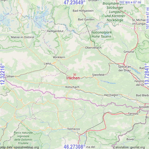
Irschen GPS coordinates[2]
46° 45' 24.984" North, 13° 1' 31.008" East
| Map corner | latitude | longitude |
|---|---|---|
| Upper-left | 47.23649°, | 12.32216° |
| Center: | 46.75694°, | 13.02528° |
| Lower-right: | 46.27308°, | 13.72841° |
| Map W x H: | 107.1×107.1 km | = 66.5×66.5mi |
| max Lat: | 48.98333° ⇑93.2% North |
| Irschen: | 46.75694° |
| min Lat: | ⇓6.8% South 46.48841° |
| min Long | Irschen | max Long |
| 9.57802° | 13.02528° | 17.1° |
| W 17.3%⇐ | ⇒82.7% E |
Elevation
Elevation of Irschen is 822 m = 2697 ft, and this is 316.5 m = 1038 ft above average elevation for this country.
| Max E: |
2140 m = 7021 ft | 13.4% |
| Irschen | 822 m 2697 ft | |
| Avg. | 505.5 m = 1658 ft | |
Min E: |
118 m = 387 ft | 86.6% |
See also: Austria elevation on elevation.city.
Geographical zone
Irschen is located in North temperate zone (between Tropic of Cancer and the Arctic Circle). Distance of this North polar circle is 2202.3 km =1368.4 mi to North.| Distance of | km | miles | from Irschen |
|---|---|---|---|
| North Pole | 4808.2 | 2987.7 | to North |
| Arctic Circle | 2202.3 | 1368.4 | to North |
| Tropic Cancer | 2593 | 1611.2 | to South |
| Equator | 5198.9 | 3230.4 | to South |


Nearby cities:
15 places around Irschen: (largest is in red/bold)
• Berg
8.1 km =5 mi,  96°
96°
• Berg im Drautal
8.4 km =5.2 mi, 95°
• Dellach
11.4 km =7.1 mi,  158°
158°
• Dellach im Drautal
4.6 km =2.9 mi,  118°
118°
• Dölsach
15.8 km =9.8 mi,  300°
300°
• Grafendorf
12.9 km =8 mi,  148°
148°
• Greifenburg
11.8 km =7.3 mi,  93°
93°
• Kötschach
8.5 km =5.3 mi,  189°
189°
• Lavant
15 km =9.3 mi,  288°
288°
• Mauthen
10.4 km =6.5 mi, 191°
• Nikolsdorf
9.1 km =5.7 mi, 290°
• Oberdrauburg
4.5 km =2.8 mi,  249°
249°
• Rangersdorf
12.8 km =8 mi,  333°
333°
• Stall
14.9 km =9.3 mi,  3°
3°
• Steinfeld
17.1 km =10.6 mi, 89°
Sources, notices
• [Note1] Compared only with cities in Austria existing in our database
• [Src1] Map data: © OpenStreetMap contributors (CC-BY-SA)
• [Src2] Other city data from geonames.org with taken over terms of usage.
• [Src3] Geographical zone / Annual Mean Temperature by Robert A. Rohde @ Wikipedia
