Gaschurn geodata
Gaschurn (Vorarlberg) is a seat of a third-order administrative division; located in Austria in Europe/Vienna (GMT+2) time zone. With population of 1,091 people, there are 1173 cities with bigger population in this country. Compared to other cities in Austria, 84.8% of cities are located further ↑North; 96.9% of cities are located further →East and 93.2% of cities have lower elevation than Gaschurn. Note1
Administrative division(s):
- Level 1: Vorarlberg
- Level 2: Politischer Bezirk Bludenz
- Level 3: Gaschurn


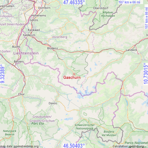
Gaschurn GPS coordinates[2]
46° 59' 9.024" North, 10° 1' 37.272" East
| Map corner | latitude | longitude |
|---|---|---|
| Upper-left | 47.46335°, | 9.32389° |
| Center: | 46.98584°, | 10.02702° |
| Lower-right: | 46.50403°, | 10.73015° |
| Map W x H: | 106.7×106.7 km | = 66.3×66.3mi |
| max Lat: | 48.98333° ⇑84.8% North |
| Gaschurn: | 46.98584° |
| min Lat: | ⇓15.2% South 46.48841° |
| min Long | Gaschurn | max Long |
| 9.57802° | 10.02702° | 17.1° |
| W 3.1%⇐ | ⇒96.9% E |
Elevation
Elevation of Gaschurn is 969 m = 3179 ft, and this is 463.5 m = 1521 ft above average elevation for this country.
| Max E: |
2140 m = 7021 ft | 6.8% |
| Gaschurn | 969 m 3179 ft | |
| Avg. | 505.5 m = 1658 ft | |
Min E: |
118 m = 387 ft | 93.2% |
See also: Austria elevation on elevation.city.
Geographical zone
Gaschurn is located in North temperate zone (between Tropic of Cancer and the Arctic Circle). Distance of this North polar circle is 2176.8 km =1352.6 mi to North.| Distance of | km | miles | from Gaschurn |
|---|---|---|---|
| North Pole | 4782.7 | 2971.8 | to North |
| Arctic Circle | 2176.8 | 1352.6 | to North |
| Tropic Cancer | 2618.4 | 1627 | to South |
| Equator | 5224.3 | 3246.2 | to South |


Nearby cities:
15 places around Gaschurn: (largest is in red/bold)
• Ausserbraz
20.5 km =12.7 mi,  332°
332°
• Bartholomäberg
14.5 km =9 mi,  318°
318°
• Dalaas
15.7 km =9.8 mi,  349°
349°
• Galtür
12 km =7.5 mi,  100°
100°
• Gortipohl
3.5 km =2.2 mi, 322°
• Innerbraz
20.1 km =12.5 mi,  335°
335°
• Ischgl
20.3 km =12.6 mi,  81°
81°
• Klösterle
16.9 km =10.5 mi,  14°
14°
• Sankt Anton im Montafon
19 km =11.8 mi, 320°
• Sankt Gallenkirch
5.6 km =3.5 mi,  313°
313°
• Schruns
12.3 km =7.6 mi, 317°
• Silbertal
12.4 km =7.7 mi, 344°
• Tschagguns
14.5 km =9 mi, 318°
• Vandans
17.3 km =10.7 mi, 314°
• Wald am Arlberg
16.4 km =10.2 mi,  1°
1°
Sources, notices
• [Note1] Compared only with cities in Austria existing in our database
• [Src1] Map data: © OpenStreetMap contributors (CC-BY-SA)
• [Src2] Other city data from geonames.org with taken over terms of usage.
• [Src3] Geographical zone / Annual Mean Temperature by Robert A. Rohde @ Wikipedia
