Gallzein geodata
Gallzein (Tyrol) is a seat of a third-order administrative division; located in Austria in Europe/Vienna (GMT+2) time zone. With population of 668 people, there are 1940 cities with bigger population in this country. Compared to other cities in Austria, 61.4% of cities are located further ↑North; 90.2% of cities are located further →East and 90.6% of cities have lower elevation than Gallzein. Note1


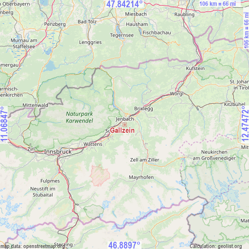
Gallzein GPS coordinates[2]
47° 22' 5.052" North, 11° 46' 17.724" East
| Map corner | latitude | longitude |
|---|---|---|
| Upper-left | 47.84214°, | 11.06847° |
| Center: | 47.36807°, | 11.77159° |
| Lower-right: | 46.8897°, | 12.47472° |
| Map W x H: | 105.9×105.9 km | = 65.8×65.8mi |
| max Lat: | 48.98333° ⇑61.4% North |
| Gallzein: | 47.36807° |
| min Lat: | ⇓38.6% South 46.48841° |
| min Long | Gallzein | max Long |
| 9.57802° | 11.77159° | 17.1° |
| W 9.8%⇐ | ⇒90.2% E |
Elevation
Elevation of Gallzein is 895 m = 2936 ft, and this is 389.5 m = 1278 ft above average elevation for this country.
| Max E: |
2140 m = 7021 ft | 9.4% |
| Gallzein | 895 m 2936 ft | |
| Avg. | 505.5 m = 1658 ft | |
Min E: |
118 m = 387 ft | 90.6% |
See also: Austria elevation on elevation.city.
Geographical zone
Gallzein is located in North temperate zone (between Tropic of Cancer and the Arctic Circle). Distance of this North polar circle is 2134.3 km =1326.2 mi to North.| Distance of | km | miles | from Gallzein |
|---|---|---|---|
| North Pole | 4740.2 | 2945.4 | to North |
| Arctic Circle | 2134.3 | 1326.2 | to North |
| Tropic Cancer | 2660.9 | 1653.4 | to South |
| Equator | 5266.8 | 3272.6 | to South |


Nearby cities:
15 places around Gallzein: (largest is in red/bold)
• Bruck am Ziller
6.5 km =4 mi,  67°
67°
• Buch in Tirol
1.5 km =0.9 mi,  298°
298°
• Eben am Achensee
5.1 km =3.2 mi,  351°
351°
• Fiecht
5.8 km =3.6 mi,  249°
249°
• Fügen
6.3 km =3.9 mi,  111°
111°
• Fügenberg
5.6 km =3.5 mi, 108°
• Jenbach
2.6 km =1.6 mi,  1°
1°
• Maurach
6.1 km =3.8 mi, 346°
• Pankrazberg
6.6 km =4.1 mi,  149°
149°
• Rofansiedlung
5.3 km =3.3 mi,  27°
27°
• Schlitters
5.3 km =3.3 mi, 74°
• Schwaz
5 km =3.1 mi, 248°
• Stans
4.1 km =2.5 mi,  267°
267°
• Strass im Zillertal
4.7 km =2.9 mi,  49°
49°
• Wiesing
4.5 km =2.8 mi, 25°
Sources, notices
• [Note1] Compared only with cities in Austria existing in our database
• [Src1] Map data: © OpenStreetMap contributors (CC-BY-SA)
• [Src2] Other city data from geonames.org with taken over terms of usage.
• [Src3] Geographical zone / Annual Mean Temperature by Robert A. Rohde @ Wikipedia
