Frannach geodata
Frannach (Styria) is a seat of a third-order administrative division; located in Austria in Europe/Vienna (GMT+2) time zone. With population of 209 people, there are 2843 cities with bigger population in this country. Compared to other cities in Austria, 87.7% of cities are located further ↑North; 70.1% of cities are located further ←West and 71.9% of cities have higher elevation than Frannach. Note1
Administrative division(s):
- Level 1: Styria
- Level 2: Politischer Bezirk Südoststeiermark
- Level 3: Pirching am Traubenberg


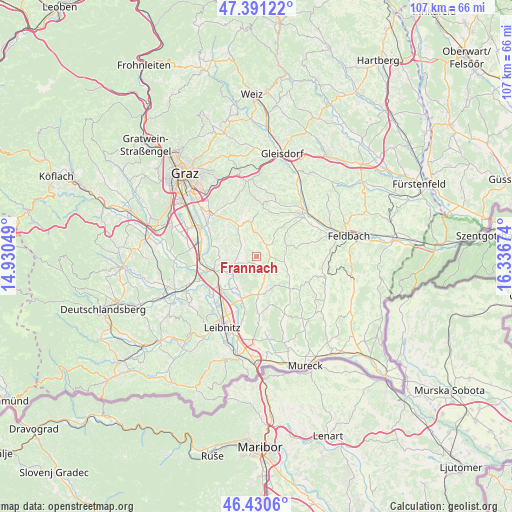
Frannach GPS coordinates[2]
46° 54' 47.016" North, 15° 38' 0.996" East
| Map corner | latitude | longitude |
|---|---|---|
| Upper-left | 47.39122°, | 14.93049° |
| Center: | 46.91306°, | 15.63361° |
| Lower-right: | 46.4306°, | 16.33674° |
| Map W x H: | 106.8×106.8 km | = 66.4×66.4mi |
| max Lat: | 48.98333° ⇑87.7% North |
| Frannach: | 46.91306° |
| min Lat: | ⇓12.3% South 46.48841° |
| min Long | Frannach | max Long |
| 9.57802° | 15.63361° | 17.1° |
| W 70.1%⇐ | ⇒29.9% E |
Elevation
Elevation of Frannach is 319 m = 1047 ft, and this is 186.5 m = 612 ft below average elevation for this country.
| Max E: |
2140 m = 7021 ft | 71.9% |
| Avg. | 505.5 m = 1658 ft | |
| Frannach | 319 m = 1047 ft | |
Min E: |
118 m = 387 ft | 28.1% |
See also: Austria elevation on elevation.city.
Geographical zone
Frannach is located in North temperate zone (between Tropic of Cancer and the Arctic Circle). Distance of this North polar circle is 2184.9 km =1357.6 mi to North.| Distance of | km | miles | from Frannach |
|---|---|---|---|
| North Pole | 4790.8 | 2976.9 | to North |
| Arctic Circle | 2184.9 | 1357.6 | to North |
| Tropic Cancer | 2610.3 | 1622 | to South |
| Equator | 5216.2 | 3241.2 | to South |


Nearby cities:
15 places around Frannach: (largest is in red/bold)
• Allerheiligen bei Wildon
6 km =3.7 mi,  271°
271°
• Breitenfeld am Tannenriegel
7 km =4.3 mi,  180°
180°
• Edelstauden
7.9 km =4.9 mi,  350°
350°
• Felgitsch
4.9 km =3 mi,  301°
301°
• Glojach
5.7 km =3.5 mi,  154°
154°
• Heiligenkreuz am Waasen
5.9 km =3.7 mi,  323°
323°
• Kirchbach in Steiermark
3 km =1.9 mi,  46°
46°
• Mitterlabill
2.7 km =1.7 mi, 176°
• Pirching am Traubenberg
4.8 km =3 mi,  328°
328°
• Sankt Georgen an der Stiefing
6 km =3.7 mi,  222°
222°
• Sankt Stefan im Rosental
5.9 km =3.7 mi,  99°
99°
• Sankt Ulrich am Waasen
7.9 km =4.9 mi,  286°
286°
• Schwarzau im Schwarzautal
4.5 km =2.8 mi, 148°
• Wolfsberg im Schwarzautal
7.9 km =4.9 mi,  165°
165°
• Zerlach
3.9 km =2.4 mi,  19°
19°
Sources, notices
• [Note1] Compared only with cities in Austria existing in our database
• [Src1] Map data: © OpenStreetMap contributors (CC-BY-SA)
• [Src2] Other city data from geonames.org with taken over terms of usage.
• [Src3] Geographical zone / Annual Mean Temperature by Robert A. Rohde @ Wikipedia
