Sankt Stefan im Rosental geodata
Sankt Stefan im Rosental (Styria) is a seat of a third-order administrative division; located in Austria in Europe/Vienna (GMT+2) time zone. With population of 3,929 people, there are 265 cities with bigger population in this country. Compared to other cities in Austria, 87.9% of cities are located further ↑North; 72.3% of cities are located further ←West and 70.2% of cities have higher elevation than Sankt Stefan im Rosental. Note1
Administrative division(s):
- Level 1: Styria
- Level 2: Politischer Bezirk Südoststeiermark
- Level 3: Sankt Stefan im Rosental
Current local time in Sankt Stefan im Rosental:
10:40 PM, FridayDifference from your time zone: hours


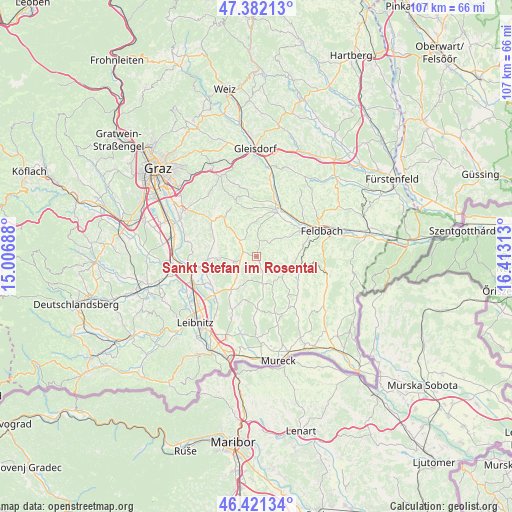
Sankt Stefan im Rosental GPS coordinates[2]
46° 54' 14.004" North, 15° 42' 36" East
| Map corner | latitude | longitude |
|---|---|---|
| Upper-left | 47.38213°, | 15.00688° |
| Center: | 46.90389°, | 15.71° |
| Lower-right: | 46.42134°, | 16.41313° |
| Map W x H: | 106.8×106.8 km | = 66.4×66.4mi |
| max Lat: | 48.98333° ⇑87.9% North |
| Sankt Stefan im Rosental: | 46.90389° |
| min Lat: | ⇓12.1% South 46.48841° |
| min Long | Sankt Stefan im | max Long |
| 9.57802° | 15.71° | 17.1° |
| W 72.3%⇐ | ⇒27.7% E |
Elevation
Elevation of Sankt Stefan im Rosental is 327 m = 1073 ft, and this is 178.5 m = 586 ft below average elevation for this country.
| Max E: |
2140 m = 7021 ft | 70.2% |
| Avg. | 505.5 m = 1658 ft | |
| Sankt Stefan im Rosental | 327 m = 1073 ft | |
Min E: |
118 m = 387 ft | 29.8% |
See also: Austria elevation on elevation.city.
Geographical zone
Sankt Stefan im Rosental is located in North temperate zone (between Tropic of Cancer and the Arctic Circle). Distance of this North polar circle is 2186 km =1358.3 mi to North.| Distance of | km | miles | from Sankt Stefan im Rosental |
|---|---|---|---|
| North Pole | 4791.8 | 2977.5 | to North |
| Arctic Circle | 2186 | 1358.3 | to North |
| Tropic Cancer | 2609.3 | 1621.3 | to South |
| Equator | 5215.2 | 3240.6 | to South |


Nearby cities:
15 places around Sankt Stefan im Rosental: (largest is in red/bold)
• Baumgarten bei Gnas
4.5 km =2.8 mi,  71°
71°
• Frannach
5.9 km =3.7 mi,  279°
279°
• Glojach
5.3 km =3.3 mi,  218°
218°
• Jagerberg
6 km =3.7 mi,  159°
159°
• Kirchbach in Steiermark
4.8 km =3 mi,  310°
310°
• Kohlberg
5.6 km =3.5 mi,  94°
94°
• Mitterlabill
5.9 km =3.7 mi,  253°
253°
• Oberdorf am Hochegg
8.4 km =5.2 mi,  6°
6°
• Paldau
7.8 km =4.8 mi,  56°
56°
• Perlsdorf
8 km =5 mi,  82°
82°
• Schwarzau im Schwarzautal
4.5 km =2.8 mi,  231°
231°
• Unterauersbach
6.3 km =3.9 mi,  132°
132°
• Wolfsberg im Schwarzautal
7.7 km =4.8 mi,  210°
210°
• Wörth bei Kirchberg an der Raab
8.2 km =5.1 mi,  31°
31°
• Zerlach
6.5 km =4 mi,  316°
316°
Sources, notices
• [Note1] Compared only with cities in Austria existing in our database
• [Src1] Map data: © OpenStreetMap contributors (CC-BY-SA)
• [Src2] Other city data from geonames.org with taken over terms of usage.
• [Src3] Geographical zone / Annual Mean Temperature by Robert A. Rohde @ Wikipedia
