Erla geodata
Erla (Lower Austria) is a populated place; located in Austria in Europe/Vienna (GMT+2) time zone. With population of 842 people, there are 1532 cities with bigger population in this country. Compared to other cities in Austria, 79.1% of cities are located further ↓South; 52.1% of cities are located further →East and 79.7% of cities have higher elevation than Erla. Note1
Administrative division(s):
- Level 1: Lower Austria
- Level 2: Politischer Bezirk Amstetten
- Level 3: St. Pantaleon-Erla


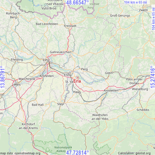
Erla GPS coordinates[2]
48° 11' 56.22" North, 14° 34' 15.708" East
| Map corner | latitude | longitude |
|---|---|---|
| Upper-left | 48.66547°, | 13.86791° |
| Center: | 48.19895°, | 14.57103° |
| Lower-right: | 47.72814°, | 15.27416° |
| Map W x H: | 104.2×104.2 km | = 64.7×64.7mi |
| max Lat: | 48.98333° ⇑20.9% North |
| Erla: | 48.19895° |
| min Lat: | ⇓79.1% South 46.48841° |
| min Long | Erla | max Long |
| 9.57802° | 14.57103° | 17.1° |
| W 47.9%⇐ | ⇒52.1% E |
Elevation
Elevation of Erla is 276 m = 906 ft, and this is 229.5 m = 753 ft below average elevation for this country.
| Max E: |
2140 m = 7021 ft | 79.7% |
| Avg. | 505.5 m = 1658 ft | |
| Erla | 276 m = 906 ft | |
Min E: |
118 m = 387 ft | 20.3% |
See also: Austria elevation on elevation.city.
Geographical zone
Erla is located in North temperate zone (between Tropic of Cancer and the Arctic Circle). Distance of this North polar circle is 2042 km =1268.8 mi to North.| Distance of | km | miles | from Erla |
|---|---|---|---|
| North Pole | 4647.8 | 2888 | to North |
| Arctic Circle | 2042 | 1268.8 | to North |
| Tropic Cancer | 2753.3 | 1710.8 | to South |
| Equator | 5359.2 | 3330.1 | to South |


Nearby cities:
15 places around Erla: (largest is in red/bold)
• Au an der Donau
3.4 km =2.1 mi,  15°
15°
• Enns
7.2 km =4.5 mi,  282°
282°
• Ennsdorf
5.2 km =3.2 mi,  285°
285°
• Heinrichsbrunn
5.6 km =3.5 mi,  331°
331°
• Hiesendorf
7 km =4.3 mi,  259°
259°
• Loitzenberg
8.3 km =5.2 mi,  350°
350°
• Mauthausen
6 km =3.7 mi,  320°
320°
• Naarn im Machlande
4 km =2.5 mi,  43°
43°
• Perg
7.3 km =4.5 mi, 39°
• Sankt Pantaleon
1.3 km =0.8 mi, 350°
• Sankt Valentin
5.4 km =3.4 mi,  228°
228°
• Schwertberg
8.3 km =5.2 mi,  6°
6°
• Strengberg
8.3 km =5.2 mi,  134°
134°
• Thaling
7.9 km =4.9 mi,  250°
250°
• Ufer
7.6 km =4.7 mi, 316°
Sources, notices
• [Note1] Compared only with cities in Austria existing in our database
• [Src1] Map data: © OpenStreetMap contributors (CC-BY-SA)
• [Src2] Other city data from geonames.org with taken over terms of usage.
• [Src3] Geographical zone / Annual Mean Temperature by Robert A. Rohde @ Wikipedia
