Empersdorf geodata
Empersdorf (Styria) is a seat of a third-order administrative division; located in Austria in Europe/Vienna (GMT+2) time zone. With population of 499 people, there are 2512 cities with bigger population in this country. Compared to other cities in Austria, 84.4% of cities are located further ↑North; 68.6% of cities are located further ←West and 63.9% of cities have higher elevation than Empersdorf. Note1
Administrative division(s):
- Level 1: Styria
- Level 2: Politischer Bezirk Leibnitz
- Level 3: Empersdorf


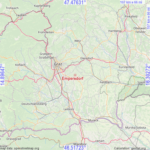
Empersdorf GPS coordinates[2]
46° 59' 56.112" North, 15° 35' 58.524" East
| Map corner | latitude | longitude |
|---|---|---|
| Upper-left | 47.47631°, | 14.89647° |
| Center: | 46.99892°, | 15.59959° |
| Lower-right: | 46.51723°, | 16.30272° |
| Map W x H: | 106.6×106.6 km | = 66.2×66.2mi |
| max Lat: | 48.98333° ⇑84.4% North |
| Empersdorf: | 46.99892° |
| min Lat: | ⇓15.6% South 46.48841° |
| min Long | Empersdorf | max Long |
| 9.57802° | 15.59959° | 17.1° |
| W 68.6%⇐ | ⇒31.4% E |
Elevation
Elevation of Empersdorf is 359 m = 1178 ft, and this is 146.5 m = 481 ft below average elevation for this country.
| Max E: |
2140 m = 7021 ft | 63.9% |
| Avg. | 505.5 m = 1658 ft | |
| Empersdorf | 359 m = 1178 ft | |
Min E: |
118 m = 387 ft | 36.1% |
See also: Austria elevation on elevation.city.
Geographical zone
Empersdorf is located in North temperate zone (between Tropic of Cancer and the Arctic Circle). Distance of this North polar circle is 2175.4 km =1351.7 mi to North.| Distance of | km | miles | from Empersdorf |
|---|---|---|---|
| North Pole | 4781.3 | 2971 | to North |
| Arctic Circle | 2175.4 | 1351.7 | to North |
| Tropic Cancer | 2619.9 | 1627.9 | to South |
| Equator | 5225.8 | 3247.2 | to South |


Nearby cities:
15 places around Empersdorf: (largest is in red/bold)
• Edelsgrub
3.8 km =2.4 mi,  0°
0°
• Edelstauden
2.2 km =1.4 mi,  143°
143°
• Felgitsch
7.2 km =4.5 mi,  192°
192°
• Hausmannstätten
6.7 km =4.2 mi,  262°
262°
• Heiligenkreuz am Waasen
4.9 km =3 mi, 190°
• Krumegg
3.4 km =2.1 mi,  44°
44°
• Langegg bei Graz
6.2 km =3.9 mi,  24°
24°
• Liebensdorf
3.1 km =1.9 mi,  232°
232°
• Nestelbach bei Graz
6.9 km =4.3 mi,  7°
7°
• Petersdorf II
6.2 km =3.9 mi,  92°
92°
• Pirching am Traubenberg
5.4 km =3.4 mi,  179°
179°
• Sankt Marein bei Graz
6.7 km =4.2 mi,  73°
73°
• Sankt Marein bei Graz-Markt
6.9 km =4.3 mi, 74°
• Vasoldsberg
3.7 km =2.3 mi,  301°
301°
• Zerlach
7.1 km =4.4 mi,  146°
146°
Sources, notices
• [Note1] Compared only with cities in Austria existing in our database
• [Src1] Map data: © OpenStreetMap contributors (CC-BY-SA)
• [Src2] Other city data from geonames.org with taken over terms of usage.
• [Src3] Geographical zone / Annual Mean Temperature by Robert A. Rohde @ Wikipedia
