Eltendorf geodata
Eltendorf (Burgenland) is a seat of a third-order administrative division; located in Austria in Europe/Vienna (GMT+2) time zone. With population of 579 people, there are 2214 cities with bigger population in this country. Compared to other cities in Austria, 83.9% of cities are located further ↑North; 86.1% of cities are located further ←West and 86.2% of cities have higher elevation than Eltendorf. Note1
Administrative division(s):
- Level 1: Burgenland
- Level 2: Politischer Bezirk Jennersdorf
- Level 3: Eltendorf


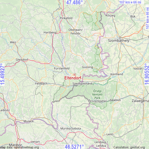
Eltendorf GPS coordinates[2]
47° 0' 31.32" North, 16° 12' 8.604" East
| Map corner | latitude | longitude |
|---|---|---|
| Upper-left | 47.486°, | 15.49927° |
| Center: | 47.0087°, | 16.20239° |
| Lower-right: | 46.5271°, | 16.90552° |
| Map W x H: | 106.6×106.6 km | = 66.2×66.2mi |
| max Lat: | 48.98333° ⇑83.9% North |
| Eltendorf: | 47.0087° |
| min Lat: | ⇓16.1% South 46.48841° |
| min Long | Eltendorf | max Long |
| 9.57802° | 16.20239° | 17.1° |
| W 86.1%⇐ | ⇒13.9% E |
Elevation
Elevation of Eltendorf is 241 m = 791 ft, and this is 264.5 m = 868 ft below average elevation for this country.
| Max E: |
2140 m = 7021 ft | 86.2% |
| Avg. | 505.5 m = 1658 ft | |
| Eltendorf | 241 m = 791 ft | |
Min E: |
118 m = 387 ft | 13.8% |
See also: Austria elevation on elevation.city.
Geographical zone
Eltendorf is located in North temperate zone (between Tropic of Cancer and the Arctic Circle). Distance of this North polar circle is 2174.3 km =1351 mi to North.| Distance of | km | miles | from Eltendorf |
|---|---|---|---|
| North Pole | 4780.2 | 2970.3 | to North |
| Arctic Circle | 2174.3 | 1351 | to North |
| Tropic Cancer | 2621 | 1628.6 | to South |
| Equator | 5226.9 | 3247.8 | to South |


Nearby cities:
15 places around Eltendorf: (largest is in red/bold)
• Dietersdorf bei Fürstenfeld
8 km =5 mi,  280°
280°
• Grieselstein
8.8 km =5.5 mi,  225°
225°
• Heiligenkreuz im Lafnitztal
4.9 km =3 mi,  116°
116°
• Inzenhof
8.7 km =5.4 mi,  84°
84°
• Kukmirn
7.4 km =4.6 mi,  4°
4°
• Königsdorf
2.9 km =1.8 mi,  250°
250°
• Limbach im Burgenland
7 km =4.3 mi,  337°
337°
• Loipersdorf bei Fürstenfeld
7.8 km =4.8 mi,  262°
262°
• Mogersdorf
7 km =4.3 mi,  161°
161°
• Neustift bei Güssing
4.7 km =2.9 mi,  67°
67°
• Rax
8.8 km =5.5 mi,  197°
197°
• Rudersdorf
8 km =5 mi,  305°
305°
• Stein
8.8 km =5.5 mi, 262°
• Tschanigraben
7.5 km =4.7 mi, 83°
• Weichselbaum
7.4 km =4.6 mi,  188°
188°
Sources, notices
• [Note1] Compared only with cities in Austria existing in our database
• [Src1] Map data: © OpenStreetMap contributors (CC-BY-SA)
• [Src2] Other city data from geonames.org with taken over terms of usage.
• [Src3] Geographical zone / Annual Mean Temperature by Robert A. Rohde @ Wikipedia
