Kukmirn geodata
Kukmirn (Burgenland) is a seat of a third-order administrative division; located in Austria in Europe/Vienna (GMT+2) time zone. With population of 718 people, there are 1808 cities with bigger population in this country. Compared to other cities in Austria, 80.5% of cities are located further ↑North; 86.3% of cities are located further ←West and 83.6% of cities have higher elevation than Kukmirn. Note1
Administrative division(s):
- Level 1: Burgenland
- Level 2: Politischer Bezirk Güssing
- Level 3: Kukmirn


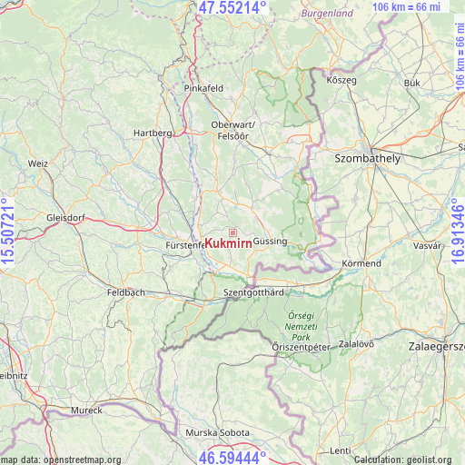
Kukmirn GPS coordinates[2]
47° 4' 31.584" North, 16° 12' 37.188" East
| Map corner | latitude | longitude |
|---|---|---|
| Upper-left | 47.55214°, | 15.50721° |
| Center: | 47.07544°, | 16.21033° |
| Lower-right: | 46.59444°, | 16.91346° |
| Map W x H: | 106.5×106.5 km | = 66.2×66.2mi |
| max Lat: | 48.98333° ⇑80.5% North |
| Kukmirn: | 47.07544° |
| min Lat: | ⇓19.5% South 46.48841° |
| min Long | Kukmirn | max Long |
| 9.57802° | 16.21033° | 17.1° |
| W 86.3%⇐ | ⇒13.7% E |
Elevation
Elevation of Kukmirn is 255 m = 837 ft, and this is 250.5 m = 822 ft below average elevation for this country.
| Max E: |
2140 m = 7021 ft | 83.6% |
| Avg. | 505.5 m = 1658 ft | |
| Kukmirn | 255 m = 837 ft | |
Min E: |
118 m = 387 ft | 16.4% |
See also: Austria elevation on elevation.city.
Geographical zone
Kukmirn is located in North temperate zone (between Tropic of Cancer and the Arctic Circle). Distance of this North polar circle is 2166.9 km =1346.4 mi to North.| Distance of | km | miles | from Kukmirn |
|---|---|---|---|
| North Pole | 4772.8 | 2965.7 | to North |
| Arctic Circle | 2166.9 | 1346.4 | to North |
| Tropic Cancer | 2628.4 | 1633.2 | to South |
| Equator | 5234.3 | 3252.4 | to South |


Nearby cities:
15 places around Kukmirn: (largest is in red/bold)
• Bocksdorf
7.9 km =4.9 mi,  341°
341°
• Deutsch Kaltenbrunn
6.3 km =3.9 mi,  289°
289°
• Deutsch Tschantschendorf
6.2 km =3.9 mi,  63°
63°
• Eltendorf
7.4 km =4.6 mi,  184°
184°
• Güssing
8.8 km =5.5 mi,  101°
101°
• Heugraben
4.9 km =3 mi, 342°
• Königsdorf
9 km =5.6 mi,  201°
201°
• Limbach im Burgenland
3.4 km =2.1 mi,  253°
253°
• Neusiedl bei Güssing
3.4 km =2.1 mi,  323°
323°
• Neustift bei Güssing
6.8 km =4.2 mi,  146°
146°
• Rohr im Burgenland
5.7 km =3.5 mi, 324°
• Rohrbrunn
9 km =5.6 mi,  307°
307°
• Rudersdorf
7.6 km =4.7 mi, 248°
• Sankt Michael im Burgenland
7.5 km =4.7 mi,  38°
38°
• Tobaj
6.8 km =4.2 mi,  82°
82°
Sources, notices
• [Note1] Compared only with cities in Austria existing in our database
• [Src1] Map data: © OpenStreetMap contributors (CC-BY-SA)
• [Src2] Other city data from geonames.org with taken over terms of usage.
• [Src3] Geographical zone / Annual Mean Temperature by Robert A. Rohde @ Wikipedia
