Eberstalzell geodata
Eberstalzell (Upper Austria) is a populated place; located in Austria in Europe/Vienna (GMT+2) time zone. With population of 1,065 people, there are 1201 cities with bigger population in this country. Compared to other cities in Austria, 69.1% of cities are located further ↓South; 65.4% of cities are located further →East and 59% of cities have higher elevation than Eberstalzell. Note1


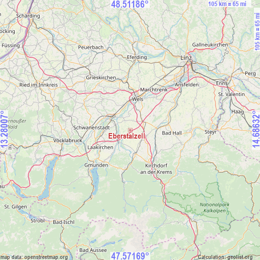
Eberstalzell GPS coordinates[2]
48° 2' 38.112" North, 13° 58' 59.484" East
| Map corner | latitude | longitude |
|---|---|---|
| Upper-left | 48.51186°, | 13.28007° |
| Center: | 48.04392°, | 13.98319° |
| Lower-right: | 47.57169°, | 14.68632° |
| Map W x H: | 104.5×104.5 km | = 64.9×64.9mi |
| max Lat: | 48.98333° ⇑30.9% North |
| Eberstalzell: | 48.04392° |
| min Lat: | ⇓69.1% South 46.48841° |
| min Long | Eberstalzell | max Long |
| 9.57802° | 13.98319° | 17.1° |
| W 34.6%⇐ | ⇒65.4% E |
Elevation
Elevation of Eberstalzell is 392 m = 1286 ft, and this is 113.5 m = 372 ft below average elevation for this country.
| Max E: |
2140 m = 7021 ft | 59% |
| Avg. | 505.5 m = 1658 ft | |
| Eberstalzell | 392 m = 1286 ft | |
Min E: |
118 m = 387 ft | 41% |
See also: Austria elevation on elevation.city.
Geographical zone
Eberstalzell is located in North temperate zone (between Tropic of Cancer and the Arctic Circle). Distance of this North polar circle is 2059.2 km =1279.5 mi to North.| Distance of | km | miles | from Eberstalzell |
|---|---|---|---|
| North Pole | 4665.1 | 2898.8 | to North |
| Arctic Circle | 2059.2 | 1279.5 | to North |
| Tropic Cancer | 2736.1 | 1700.1 | to South |
| Equator | 5342 | 3319.4 | to South |


Nearby cities:
15 places around Eberstalzell: (largest is in red/bold)
• Dürndorf
10 km =6.2 mi,  165°
165°
• Graben
8.8 km =5.5 mi,  315°
315°
• Kropfing
7.9 km =4.9 mi,  311°
311°
• Lambach
9.7 km =6 mi,  303°
303°
• Mitterndorf
10 km =6.2 mi, 173°
• Pettenbach
9.6 km =6 mi,  164°
164°
• Ried im Traunkreis
7.1 km =4.4 mi,  106°
106°
• Sattledt
6.3 km =3.9 mi,  58°
58°
• Stadl-Paura
9.7 km =6 mi, 296°
• Stadl-Traun
9.9 km =6.2 mi,  293°
293°
• Steinerkirchen an der Traun
4.3 km =2.7 mi,  334°
334°
• Steinhaus
8.5 km =5.3 mi,  18°
18°
• Vorchdorf
6.4 km =4 mi,  225°
225°
• Wimsbach
6.7 km =4.2 mi, 292°
• Wipfing
0.5 km =0.3 mi,  26°
26°
Sources, notices
• [Note1] Compared only with cities in Austria existing in our database
• [Src1] Map data: © OpenStreetMap contributors (CC-BY-SA)
• [Src2] Other city data from geonames.org with taken over terms of usage.
• [Src3] Geographical zone / Annual Mean Temperature by Robert A. Rohde @ Wikipedia
