Stadl-Traun geodata
Stadl-Traun (Upper Austria) is a populated place; located in Austria in Europe/Vienna (GMT+2) time zone. With population of 3,643 people, there are 294 cities with bigger population in this country. Compared to other cities in Austria, 71.4% of cities are located further ↓South; 67.7% of cities are located further →East and 65.9% of cities have higher elevation than Stadl-Traun. Note1


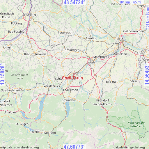
Stadl-Traun GPS coordinates[2]
48° 4' 46.668" North, 13° 51' 41.04" East
| Map corner | latitude | longitude |
|---|---|---|
| Upper-left | 48.54724°, | 13.15828° |
| Center: | 48.07963°, | 13.8614° |
| Lower-right: | 47.60773°, | 14.56453° |
| Map W x H: | 104.5×104.5 km | = 64.9×64.9mi |
| max Lat: | 48.98333° ⇑28.6% North |
| Stadl-Traun: | 48.07963° |
| min Lat: | ⇓71.4% South 46.48841° |
| min Long | Stadl-Traun | max Long |
| 9.57802° | 13.8614° | 17.1° |
| W 32.3%⇐ | ⇒67.7% E |
Elevation
Elevation of Stadl-Traun is 349 m = 1145 ft, and this is 156.5 m = 513 ft below average elevation for this country.
| Max E: |
2140 m = 7021 ft | 65.9% |
| Avg. | 505.5 m = 1658 ft | |
| Stadl-Traun | 349 m = 1145 ft | |
Min E: |
118 m = 387 ft | 34.1% |
See also: Austria elevation on elevation.city.
Geographical zone
Stadl-Traun is located in North temperate zone (between Tropic of Cancer and the Arctic Circle). Distance of this North polar circle is 2055.2 km =1277 mi to North.| Distance of | km | miles | from Stadl-Traun |
|---|---|---|---|
| North Pole | 4661.1 | 2896.3 | to North |
| Arctic Circle | 2055.2 | 1277 | to North |
| Tropic Cancer | 2740 | 1702.6 | to South |
| Equator | 5346 | 3321.8 | to South |


Nearby cities:
15 places around Stadl-Traun: (largest is in red/bold)
• Aichkirchen
6.2 km =3.9 mi,  302°
302°
• Edt bei Lambach
4.4 km =2.7 mi,  21°
21°
• Graben
3.7 km =2.3 mi,  51°
51°
• Kaufing
5.3 km =3.3 mi,  239°
239°
• Kropfing
3.4 km =2.1 mi,  67°
67°
• Lambach
1.8 km =1.1 mi,  33°
33°
• Neukirchen bei Lambach
4 km =2.5 mi, 304°
• Pennewang
6 km =3.7 mi,  351°
351°
• Roitham
6.8 km =4.2 mi,  205°
205°
• Rüstorf
6.7 km =4.2 mi,  232°
232°
• Schlatt
5.4 km =3.4 mi,  260°
260°
• Schwanenstadt
7 km =4.3 mi,  247°
247°
• Stadl-Hausruck
0.8 km =0.5 mi, 295°
• Stadl-Paura
0.6 km =0.4 mi,  43°
43°
• Wimsbach
3.2 km =2 mi,  116°
116°
Sources, notices
• [Note1] Compared only with cities in Austria existing in our database
• [Src1] Map data: © OpenStreetMap contributors (CC-BY-SA)
• [Src2] Other city data from geonames.org with taken over terms of usage.
• [Src3] Geographical zone / Annual Mean Temperature by Robert A. Rohde @ Wikipedia
