Wimsbach geodata
Wimsbach (Upper Austria) is a seat of a third-order administrative division; located in Austria in Europe/Vienna (GMT+2) time zone. With population of 1,164 people, there are 1087 cities with bigger population in this country. Compared to other cities in Austria, 70.4% of cities are located further ↓South; 66.9% of cities are located further →East and 60.5% of cities have higher elevation than Wimsbach. Note1
Administrative division(s):
- Level 1: Upper Austria
- Level 2: Wels-Land
- Level 3: Bad Wimsbach-Neydharting


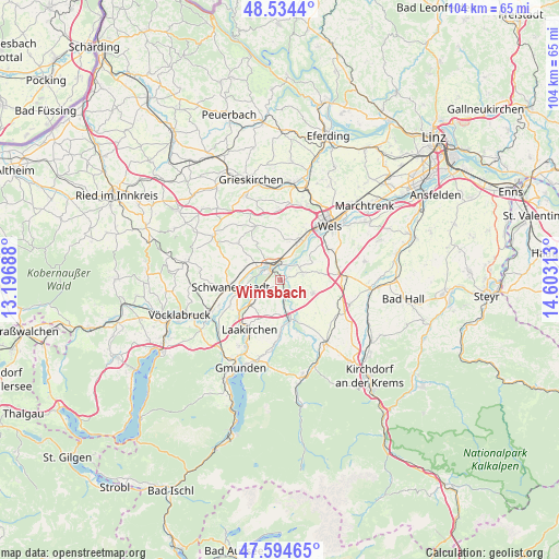
Wimsbach GPS coordinates[2]
48° 4' 0.012" North, 13° 54' 0" East
| Map corner | latitude | longitude |
|---|---|---|
| Upper-left | 48.5344°, | 13.19688° |
| Center: | 48.06667°, | 13.9° |
| Lower-right: | 47.59465°, | 14.60313° |
| Map W x H: | 104.5×104.5 km | = 64.9×64.9mi |
| max Lat: | 48.98333° ⇑29.6% North |
| Wimsbach: | 48.06667° |
| min Lat: | ⇓70.4% South 46.48841° |
| min Long | Wimsbach | max Long |
| 9.57802° | 13.9° | 17.1° |
| W 33.1%⇐ | ⇒66.9% E |
Elevation
Elevation of Wimsbach is 380 m = 1247 ft, and this is 125.5 m = 412 ft below average elevation for this country.
| Max E: |
2140 m = 7021 ft | 60.5% |
| Avg. | 505.5 m = 1658 ft | |
| Wimsbach | 380 m = 1247 ft | |
Min E: |
118 m = 387 ft | 39.5% |
See also: Austria elevation on elevation.city.
Geographical zone
Wimsbach is located in North temperate zone (between Tropic of Cancer and the Arctic Circle). Distance of this North polar circle is 2056.7 km =1278 mi to North.| Distance of | km | miles | from Wimsbach |
|---|---|---|---|
| North Pole | 4662.5 | 2897.1 | to North |
| Arctic Circle | 2056.7 | 1278 | to North |
| Tropic Cancer | 2738.6 | 1701.7 | to South |
| Equator | 5344.5 | 3320.9 | to South |


Nearby cities:
15 places around Wimsbach: (largest is in red/bold)
• Eberstalzell
6.7 km =4.2 mi,  112°
112°
• Edt bei Lambach
5.7 km =3.5 mi,  347°
347°
• Graben
3.7 km =2.3 mi,  0°
0°
• Gunskirchen
8.3 km =5.2 mi,  26°
26°
• Kaufing
7.5 km =4.7 mi,  260°
260°
• Kropfing
2.8 km =1.7 mi,  5°
5°
• Lambach
3.5 km =2.2 mi,  326°
326°
• Neukirchen bei Lambach
7.2 km =4.5 mi,  300°
300°
• Roitham
7.5 km =4.7 mi,  231°
231°
• Stadl-Hausruck
4 km =2.5 mi, 296°
• Stadl-Paura
3.1 km =1.9 mi,  306°
306°
• Stadl-Traun
3.2 km =2 mi, 296°
• Steinerkirchen an der Traun
4.5 km =2.8 mi,  72°
72°
• Vorchdorf
7.2 km =4.5 mi,  167°
167°
• Wipfing
6.7 km =4.2 mi, 108°
Sources, notices
• [Note1] Compared only with cities in Austria existing in our database
• [Src1] Map data: © OpenStreetMap contributors (CC-BY-SA)
• [Src2] Other city data from geonames.org with taken over terms of usage.
• [Src3] Geographical zone / Annual Mean Temperature by Robert A. Rohde @ Wikipedia
