Buchkirchen geodata
Buchkirchen (Upper Austria) is a seat of a third-order administrative division; located in Austria in Europe/Vienna (GMT+2) time zone. With population of 700 people, there are 1854 cities with bigger population in this country. Compared to other cities in Austria, 80.9% of cities are located further ↓South; 64.3% of cities are located further →East and 68.3% of cities have higher elevation than Buchkirchen. Note1


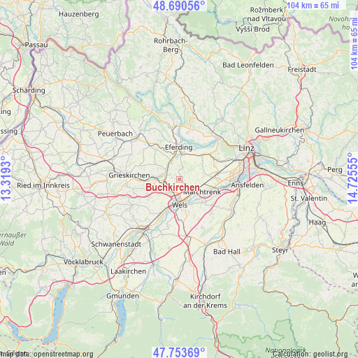
Buchkirchen GPS coordinates[2]
48° 13' 27.372" North, 14° 1' 20.712" East
| Map corner | latitude | longitude |
|---|---|---|
| Upper-left | 48.69056°, | 13.3193° |
| Center: | 48.22427°, | 14.02242° |
| Lower-right: | 47.75369°, | 14.72555° |
| Map W x H: | 104.2×104.2 km | = 64.7×64.7mi |
| max Lat: | 48.98333° ⇑19.1% North |
| Buchkirchen: | 48.22427° |
| min Lat: | ⇓80.9% South 46.48841° |
| min Long | Buchkirchen | max Long |
| 9.57802° | 14.02242° | 17.1° |
| W 35.7%⇐ | ⇒64.3% E |
Elevation
Elevation of Buchkirchen is 337 m = 1106 ft, and this is 168.5 m = 553 ft below average elevation for this country.
| Max E: |
2140 m = 7021 ft | 68.3% |
| Avg. | 505.5 m = 1658 ft | |
| Buchkirchen | 337 m = 1106 ft | |
Min E: |
118 m = 387 ft | 31.7% |
See also: Austria elevation on elevation.city.
Geographical zone
Buchkirchen is located in North temperate zone (between Tropic of Cancer and the Arctic Circle). Distance of this North polar circle is 2039.1 km =1267 mi to North.| Distance of | km | miles | from Buchkirchen |
|---|---|---|---|
| North Pole | 4645 | 2886.3 | to North |
| Arctic Circle | 2039.1 | 1267 | to North |
| Tropic Cancer | 2756.1 | 1712.6 | to South |
| Equator | 5362 | 3331.8 | to South |


Nearby cities:
15 places around Buchkirchen: (largest is in red/bold)
• Dickerldorf
5.9 km =3.7 mi,  154°
154°
• Fraham
6.6 km =4.1 mi,  5°
5°
• Haidl
6.2 km =3.9 mi,  158°
158°
• Holzhausen
5.5 km =3.4 mi,  91°
91°
• Krenglbach
5.4 km =3.4 mi,  246°
246°
• Laahen
5.9 km =3.7 mi,  191°
191°
• Mitterperwend
5.6 km =3.5 mi,  111°
111°
• Niederthan
4.8 km =3 mi,  200°
200°
• Oberhaid
5.4 km =3.4 mi, 185°
• Oberhart
5 km =3.1 mi, 155°
• Pernau
6.5 km =4 mi,  172°
172°
• Untereisenfeld
6.4 km =4 mi, 167°
• Unterhart
6.1 km =3.8 mi,  122°
122°
• Wallern an der Trattnach
5.7 km =3.5 mi,  279°
279°
• Wels
6.5 km =4 mi, 172°
Sources, notices
• [Note1] Compared only with cities in Austria existing in our database
• [Src1] Map data: © OpenStreetMap contributors (CC-BY-SA)
• [Src2] Other city data from geonames.org with taken over terms of usage.
• [Src3] Geographical zone / Annual Mean Temperature by Robert A. Rohde @ Wikipedia
