Böhlerwerk geodata
Böhlerwerk (Lower Austria) is a populated place; located in Austria in Europe/Vienna (GMT+2) time zone. With population of 989 people, there are 1314 cities with bigger population in this country. Compared to other cities in Austria, 65.3% of cities are located further ↓South; 50.5% of cities are located further ←West and 65.2% of cities have higher elevation than Böhlerwerk. Note1
Administrative division(s):
- Level 1: Lower Austria
- Level 2: Politischer Bezirk Amstetten
- Level 3: Sonntagberg


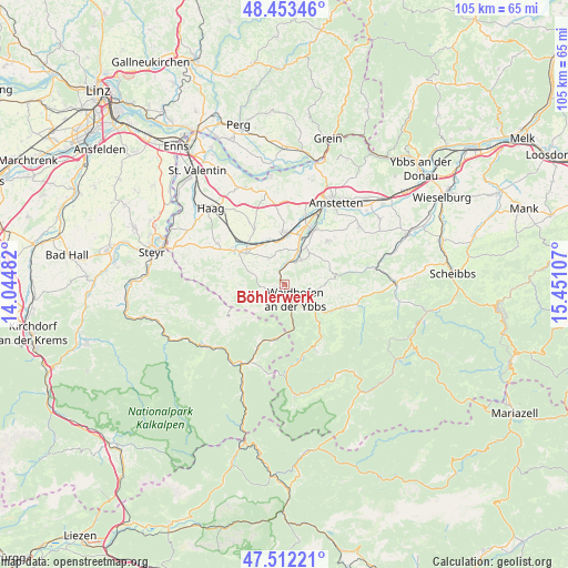
Böhlerwerk GPS coordinates[2]
47° 59' 5.928" North, 14° 44' 52.584" East
| Map corner | latitude | longitude |
|---|---|---|
| Upper-left | 48.45346°, | 14.04482° |
| Center: | 47.98498°, | 14.74794° |
| Lower-right: | 47.51221°, | 15.45107° |
| Map W x H: | 104.7×104.7 km | = 65.1×65.1mi |
| max Lat: | 48.98333° ⇑34.7% North |
| Böhlerwerk: | 47.98498° |
| min Lat: | ⇓65.3% South 46.48841° |
| min Long | Böhlerwerk | max Long |
| 9.57802° | 14.74794° | 17.1° |
| W 50.5%⇐ | ⇒49.5% E |
Elevation
Elevation of Böhlerwerk is 353 m = 1158 ft, and this is 152.5 m = 500 ft below average elevation for this country.
| Max E: |
2140 m = 7021 ft | 65.2% |
| Avg. | 505.5 m = 1658 ft | |
| Böhlerwerk | 353 m = 1158 ft | |
Min E: |
118 m = 387 ft | 34.8% |
See also: Austria elevation on elevation.city.
Geographical zone
Böhlerwerk is located in North temperate zone (between Tropic of Cancer and the Arctic Circle). Distance of this North polar circle is 2065.7 km =1283.6 mi to North.| Distance of | km | miles | from Böhlerwerk |
|---|---|---|---|
| North Pole | 4671.6 | 2902.8 | to North |
| Arctic Circle | 2065.7 | 1283.6 | to North |
| Tropic Cancer | 2729.5 | 1696 | to South |
| Equator | 5335.4 | 3315.3 | to South |


Nearby cities:
15 places around Böhlerwerk: (largest is in red/bold)
• Allhartsberg
5.6 km =3.5 mi,  34°
34°
• Aschbach Markt
9.7 km =6 mi,  2°
2°
• Biberbach
5.8 km =3.6 mi,  329°
329°
• Ertl
8.7 km =5.4 mi,  264°
264°
• Kematen an der Ybbs
4.7 km =2.9 mi,  15°
15°
• Konradsheim
4.5 km =2.8 mi,  210°
210°
• Rosenau am Sonntagberg
2.6 km =1.6 mi,  345°
345°
• Sankt Georgen in der Klaus
3.6 km =2.2 mi,  267°
267°
• Seitenstetten Markt
9.1 km =5.7 mi,  306°
306°
• Sonntagberg
1.5 km =0.9 mi,  38°
38°
• Waidhofen an der Ybbs
3.4 km =2.1 mi,  145°
145°
• Windhag
4.1 km =2.5 mi,  99°
99°
• Wirts
5.9 km =3.7 mi,  168°
168°
• Zell-Arzberg
5 km =3.1 mi,  137°
137°
• Zell-Markt
3.9 km =2.4 mi, 137°
Sources, notices
• [Note1] Compared only with cities in Austria existing in our database
• [Src1] Map data: © OpenStreetMap contributors (CC-BY-SA)
• [Src2] Other city data from geonames.org with taken over terms of usage.
• [Src3] Geographical zone / Annual Mean Temperature by Robert A. Rohde @ Wikipedia
