Allhartsberg geodata
Allhartsberg (Lower Austria) is a seat of a third-order administrative division; located in Austria in Europe/Vienna (GMT+2) time zone. With population of 999 people, there are 1293 cities with bigger population in this country. Compared to other cities in Austria, 68.3% of cities are located further ↓South; 51.1% of cities are located further ←West and 59.3% of cities have higher elevation than Allhartsberg. Note1
Administrative division(s):
- Level 1: Lower Austria
- Level 2: Politischer Bezirk Amstetten
- Level 3: Allhartsberg


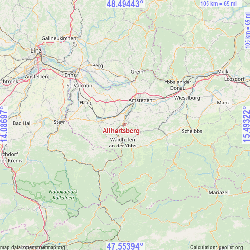
Allhartsberg GPS coordinates[2]
48° 1' 34.788" North, 14° 47' 24.324" East
| Map corner | latitude | longitude |
|---|---|---|
| Upper-left | 48.49443°, | 14.08697° |
| Center: | 48.02633°, | 14.79009° |
| Lower-right: | 47.55394°, | 15.49322° |
| Map W x H: | 104.6×104.6 km | = 65×65mi |
| max Lat: | 48.98333° ⇑31.7% North |
| Allhartsberg: | 48.02633° |
| min Lat: | ⇓68.3% South 46.48841° |
| min Long | Allhartsberg | max Long |
| 9.57802° | 14.79009° | 17.1° |
| W 51.1%⇐ | ⇒48.9% E |
Elevation
Elevation of Allhartsberg is 390 m = 1280 ft, and this is 115.5 m = 379 ft below average elevation for this country.
| Max E: |
2140 m = 7021 ft | 59.3% |
| Avg. | 505.5 m = 1658 ft | |
| Allhartsberg | 390 m = 1280 ft | |
Min E: |
118 m = 387 ft | 40.7% |
See also: Austria elevation on elevation.city.
Geographical zone
Allhartsberg is located in North temperate zone (between Tropic of Cancer and the Arctic Circle). Distance of this North polar circle is 2061.1 km =1280.7 mi to North.| Distance of | km | miles | from Allhartsberg |
|---|---|---|---|
| North Pole | 4667 | 2899.9 | to North |
| Arctic Circle | 2061.1 | 1280.7 | to North |
| Tropic Cancer | 2734.1 | 1698.9 | to South |
| Equator | 5340 | 3318.1 | to South |


Nearby cities:
15 places around Allhartsberg: (largest is in red/bold)
• Aschbach Markt
5.8 km =3.6 mi,  332°
332°
• Biberbach
6.1 km =3.8 mi,  273°
273°
• Böhlerwerk
5.6 km =3.5 mi,  214°
214°
• Hausmening
5.3 km =3.3 mi,  20°
20°
• Kematen an der Ybbs
1.9 km =1.2 mi, 266°
• Mauer bei Amstetten
7.8 km =4.8 mi,  5°
5°
• Mitterhausleiten
7.7 km =4.8 mi,  318°
318°
• Neufurth
6.1 km =3.8 mi, 15°
• Neuhofen an der Ybbs
6 km =3.7 mi,  53°
53°
• Rosenau am Sonntagberg
4.3 km =2.7 mi,  241°
241°
• Sonntagberg
4.1 km =2.5 mi, 212°
• Ulmerfeld
6 km =3.7 mi, 20°
• Waidhofen an der Ybbs
7.5 km =4.7 mi,  189°
189°
• Windhag
5.3 km =3.3 mi,  170°
170°
• Zell-Markt
7.5 km =4.7 mi,  183°
183°
Sources, notices
• [Note1] Compared only with cities in Austria existing in our database
• [Src1] Map data: © OpenStreetMap contributors (CC-BY-SA)
• [Src2] Other city data from geonames.org with taken over terms of usage.
• [Src3] Geographical zone / Annual Mean Temperature by Robert A. Rohde @ Wikipedia
