Zell-Markt geodata
Zell-Markt (Lower Austria) is a section of populated place; located in Austria in Europe/Vienna (GMT+1) time zone. With population of 1,119 people, there are 1136 cities with bigger population in this country. Compared to other cities in Austria, 63.9% of cities are located further ↓South; 51% of cities are located further ←West and 63% of cities have higher elevation than Zell-Markt. Note1
Administrative division(s):
- Level 1: Lower Austria
- Level 2: Waidhofen an der Ybbs Stadt
- Level 3: Waidhofen an der Ybbs


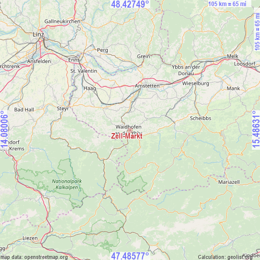
Zell-Markt GPS coordinates[2]
47° 57' 31.608" North, 14° 46' 59.448" East
| Map corner | latitude | longitude |
|---|---|---|
| Upper-left | 48.42749°, | 14.08006° |
| Center: | 47.95878°, | 14.78318° |
| Lower-right: | 47.48577°, | 15.48631° |
| Map W x H: | 104.7×104.7 km | = 65.1×65.1mi |
| max Lat: | 48.98333° ⇑36.1% North |
| Zell-Markt: | 47.95878° |
| min Lat: | ⇓63.9% South 46.48841° |
| min Long | Zell-Markt | max Long |
| 9.57802° | 14.78318° | 17.1° |
| W 51%⇐ | ⇒49% E |
Elevation
Elevation of Zell-Markt is 363 m = 1191 ft, and this is 142.5 m = 468 ft below average elevation for this country.
| Max E: |
2140 m = 7021 ft | 63% |
| Avg. | 505.5 m = 1658 ft | |
| Zell-Markt | 363 m = 1191 ft | |
Min E: |
118 m = 387 ft | 37% |
See also: Austria elevation on elevation.city.
Geographical zone
Zell-Markt is located in North temperate zone (between Tropic of Cancer and the Arctic Circle). Distance of this North polar circle is 2068.7 km =1285.4 mi to North.| Distance of | km | miles | from Zell-Markt |
|---|---|---|---|
| North Pole | 4674.5 | 2904.6 | to North |
| Arctic Circle | 2068.7 | 1285.4 | to North |
| Tropic Cancer | 2726.6 | 1694.2 | to South |
| Equator | 5332.5 | 3313.5 | to South |


Nearby cities:
15 places around Zell-Markt: (largest is in red/bold)
• Allhartsberg
7.5 km =4.7 mi,  3°
3°
• Biberbach
9.7 km =6 mi,  324°
324°
• Böhlerwerk
3.9 km =2.4 mi, 317°
• Gaflenz
8.3 km =5.2 mi,  211°
211°
• Kematen an der Ybbs
7.5 km =4.7 mi,  349°
349°
• Konradsheim
5 km =3.1 mi,  258°
258°
• Opponitz
9.5 km =5.9 mi,  161°
161°
• Rosenau am Sonntagberg
6.4 km =4 mi,  329°
329°
• Sankt Georgen in der Klaus
6.8 km =4.2 mi,  293°
293°
• Sonntagberg
4.4 km =2.7 mi,  337°
337°
• Waidhofen an der Ybbs
0.7 km =0.4 mi,  281°
281°
• Windhag
2.7 km =1.7 mi,  32°
32°
• Wirts
3.2 km =2 mi, 207°
• Ybbsitz
8.2 km =5.1 mi,  98°
98°
• Zell-Arzberg
1.1 km =0.7 mi,  135°
135°
Sources, notices
• [Note1] Compared only with cities in Austria existing in our database
• [Src1] Map data: © OpenStreetMap contributors (CC-BY-SA)
• [Src2] Other city data from geonames.org with taken over terms of usage.
• [Src3] Geographical zone / Annual Mean Temperature by Robert A. Rohde @ Wikipedia
