Wirts geodata
Wirts (Lower Austria) is a populated place; located in Austria in Europe/Vienna (GMT+2) time zone. With population of 543 people, there are 2346 cities with bigger population in this country. Compared to other cities in Austria, 62.3% of cities are located further ↓South; 50.7% of cities are located further ←West and 50.6% of cities have lower elevation than Wirts. Note1
Administrative division(s):
- Level 1: Lower Austria
- Level 2: Waidhofen an der Ybbs Stadt
- Level 3: Waidhofen an der Ybbs


Wirts GPS coordinates[2]
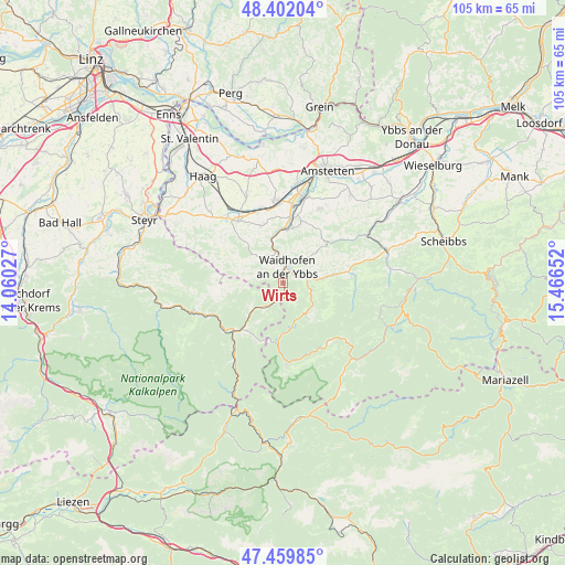
47° 55' 59.124" North, 14° 45' 48.204" East
| Map corner | latitude | longitude |
|---|---|---|
| Upper-left | 48.40204°, | 14.06027° |
| Center: | 47.93309°, | 14.76339° |
| Lower-right: | 47.45985°, | 15.46652° |
| Map W x H: | 104.8×104.8 km | = 65.1×65.1mi |
| max Lat: | 48.98333° ⇑37.7% North |
| Wirts: | 47.93309° |
| min Lat: | ⇓62.3% South 46.48841° |
| min Long | Wirts | max Long |
| 9.57802° | 14.76339° | 17.1° |
| W 50.7%⇐ | ⇒49.3% E |
Elevation
Elevation of Wirts is 453 m = 1486 ft, and this is 52.5 m = 172 ft below average elevation for this country.
| Max E: |
2140 m = 7021 ft | 49.4% |
| Avg. | 505.5 m = 1658 ft | |
| Wirts | 453 m = 1486 ft | |
Min E: |
118 m = 387 ft | 50.6% |
See also: Austria elevation on elevation.city.
Geographical zone
Wirts is located in North temperate zone (between Tropic of Cancer and the Arctic Circle). Distance of this North polar circle is 2071.5 km =1287.2 mi to North.| Distance of | km | miles | from Wirts |
|---|---|---|---|
| North Pole | 4677.4 | 2906.4 | to North |
| Arctic Circle | 2071.5 | 1287.2 | to North |
| Tropic Cancer | 2723.7 | 1692.4 | to South |
| Equator | 5329.7 | 3311.7 | to South |


Nearby cities:
15 places around Wirts: (largest is in red/bold)
• Allhartsberg
10.6 km =6.6 mi,  10°
10°
• Böhlerwerk
5.9 km =3.7 mi,  348°
348°
• Ertl
11 km =6.8 mi,  296°
296°
• Gaflenz
5.1 km =3.2 mi,  214°
214°
• Kematen an der Ybbs
10.3 km =6.4 mi,  0°
0°
• Konradsheim
4 km =2.5 mi, 298°
• Opponitz
7.6 km =4.7 mi,  144°
144°
• Rosenau am Sonntagberg
8.5 km =5.3 mi, 347°
• Sankt Georgen in der Klaus
7.3 km =4.5 mi,  319°
319°
• Sonntagberg
7 km =4.3 mi,  358°
358°
• Waidhofen an der Ybbs
3.1 km =1.9 mi, 14°
• Windhag
5.9 km =3.7 mi,  29°
29°
• Ybbsitz
9.7 km =6 mi,  80°
80°
• Zell-Arzberg
3.1 km =1.9 mi,  46°
46°
• Zell-Markt
3.2 km =2 mi, 27°
Sources, notices
• [Note1] Compared only with cities in Austria existing in our database
• [Src1] Map data: © OpenStreetMap contributors (CC-BY-SA)
• [Src2] Other city data from geonames.org with taken over terms of usage.
• [Src3] Geographical zone / Annual Mean Temperature by Robert A. Rohde @ Wikipedia
