Bildstein geodata
Bildstein (Vorarlberg) is a seat of a third-order administrative division; located in Austria in Europe/Vienna (GMT+2) time zone. With population of 766 people, there are 1687 cities with bigger population in this country. Compared to other cities in Austria, 56.5% of cities are located further ↑North; 98.5% of cities are located further →East and 53.4% of cities have lower elevation than Bildstein. Note1
Administrative division(s):
- Level 1: Vorarlberg
- Level 2: Politischer Bezirk Bregenz
- Level 3: Bildstein


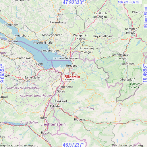
Bildstein GPS coordinates[2]
47° 27' 0" North, 9° 46' 0.012" East
| Map corner | latitude | longitude |
|---|---|---|
| Upper-left | 47.92333°, | 9.06354° |
| Center: | 47.45°, | 9.76667° |
| Lower-right: | 46.97237°, | 10.4698° |
| Map W x H: | 105.7×105.7 km | = 65.7×65.7mi |
| max Lat: | 48.98333° ⇑56.5% North |
| Bildstein: | 47.45° |
| min Lat: | ⇓43.5% South 46.48841° |
| min Long | Bildstein | max Long |
| 9.57802° | 9.76667° | 17.1° |
| W 1.5%⇐ | ⇒98.5% E |
Elevation
Elevation of Bildstein is 474 m = 1555 ft, and this is 31.5 m = 103 ft below average elevation for this country.
| Max E: |
2140 m = 7021 ft | 46.6% |
| Avg. | 505.5 m = 1658 ft | |
| Bildstein | 474 m = 1555 ft | |
Min E: |
118 m = 387 ft | 53.4% |
See also: Austria elevation on elevation.city.
Geographical zone
Bildstein is located in North temperate zone (between Tropic of Cancer and the Arctic Circle). Distance of this North polar circle is 2125.2 km =1320.5 mi to North.| Distance of | km | miles | from Bildstein |
|---|---|---|---|
| North Pole | 4731.1 | 2939.8 | to North |
| Arctic Circle | 2125.2 | 1320.5 | to North |
| Tropic Cancer | 2670 | 1659.1 | to South |
| Equator | 5275.9 | 3278.3 | to South |


Nearby cities:
15 places around Bildstein: (largest is in red/bold)
• Alberschwende
4.9 km =3 mi,  89°
89°
• Bregenz
6.1 km =3.8 mi,  346°
346°
• Buch
5.7 km =3.5 mi,  45°
45°
• Dornbirn
4.4 km =2.7 mi,  205°
205°
• Eichenberg
9.3 km =5.8 mi,  7°
7°
• Fußach
8.5 km =5.3 mi,  292°
292°
• Hard
7.3 km =4.5 mi,  300°
300°
• Kennelbach
3.7 km =2.3 mi,  0°
0°
• Langen
8.3 km =5.2 mi,  26°
26°
• Lauterach
4 km =2.5 mi,  315°
315°
• Lochau
9.3 km =5.8 mi, 352°
• Lustenau
8.5 km =5.3 mi,  252°
252°
• Schwarzach
0.4 km =0.2 mi, 252°
• Schwarzenberg
7.5 km =4.7 mi,  121°
121°
• Wolfurt
2.2 km =1.4 mi,  325°
325°
Sources, notices
• [Note1] Compared only with cities in Austria existing in our database
• [Src1] Map data: © OpenStreetMap contributors (CC-BY-SA)
• [Src2] Other city data from geonames.org with taken over terms of usage.
• [Src3] Geographical zone / Annual Mean Temperature by Robert A. Rohde @ Wikipedia
