Schwarzenberg geodata
Schwarzenberg (Vorarlberg) is a populated place; located in Austria in Europe/Vienna (GMT+2) time zone. With population of 1,850 people, there are 671 cities with bigger population in this country. Compared to other cities in Austria, 58.8% of cities are located further ↑North; 97.9% of cities are located further →East and 79.3% of cities have lower elevation than Schwarzenberg. Note1
Administrative division(s):
- Level 1: Vorarlberg
- Level 2: Politischer Bezirk Bregenz
- Level 3: Schwarzenberg


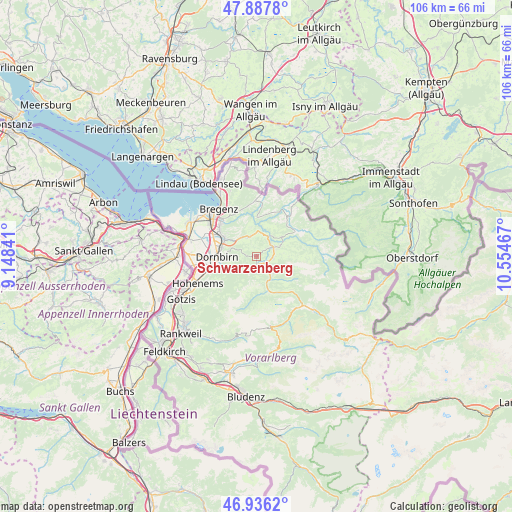
Schwarzenberg GPS coordinates[2]
47° 24' 50.94" North, 9° 51' 5.544" East
| Map corner | latitude | longitude |
|---|---|---|
| Upper-left | 47.8878°, | 9.14841° |
| Center: | 47.41415°, | 9.85154° |
| Lower-right: | 46.9362°, | 10.55467° |
| Map W x H: | 105.8×105.8 km | = 65.7×65.7mi |
| max Lat: | 48.98333° ⇑58.8% North |
| Schwarzenberg: | 47.41415° |
| min Lat: | ⇓41.2% South 46.48841° |
| min Long | Schwarzenberg | max Long |
| 9.57802° | 9.85154° | 17.1° |
| W 2.1%⇐ | ⇒97.9% E |
Elevation
Elevation of Schwarzenberg is 703 m = 2306 ft, and this is 197.5 m = 648 ft above average elevation for this country.
| Max E: |
2140 m = 7021 ft | 20.7% |
| Schwarzenberg | 703 m 2306 ft | |
| Avg. | 505.5 m = 1658 ft | |
Min E: |
118 m = 387 ft | 79.3% |
See also: Austria elevation on elevation.city.
Geographical zone
Schwarzenberg is located in North temperate zone (between Tropic of Cancer and the Arctic Circle). Distance of this North polar circle is 2129.2 km =1323 mi to North.| Distance of | km | miles | from Schwarzenberg |
|---|---|---|---|
| North Pole | 4735.1 | 2942.3 | to North |
| Arctic Circle | 2129.2 | 1323 | to North |
| Tropic Cancer | 2666 | 1656.6 | to South |
| Equator | 5272 | 3275.9 | to South |


Nearby cities:
15 places around Schwarzenberg: (largest is in red/bold)
• Alberschwende
4.3 km =2.7 mi,  339°
339°
• Andelsbuch
3.2 km =2 mi,  95°
95°
• Bezau
5 km =3.1 mi,  131°
131°
• Bildstein
7.5 km =4.7 mi,  301°
301°
• Bizau
7.7 km =4.8 mi, 130°
• Buch
8.3 km =5.2 mi, 343°
• Doren
9 km =5.6 mi,  13°
13°
• Dornbirn
8.2 km =5.1 mi,  270°
270°
• Egg
4 km =2.5 mi,  60°
60°
• Großdorf
5.3 km =3.3 mi,  65°
65°
• Langenegg
7 km =4.3 mi,  29°
29°
• Lingenau
6.6 km =4.1 mi,  52°
52°
• Mellau
7.4 km =4.6 mi,  162°
162°
• Reuthe
5.8 km =3.6 mi,  145°
145°
• Schwarzach
7.8 km =4.8 mi, 299°
Sources, notices
• [Note1] Compared only with cities in Austria existing in our database
• [Src1] Map data: © OpenStreetMap contributors (CC-BY-SA)
• [Src2] Other city data from geonames.org with taken over terms of usage.
• [Src3] Geographical zone / Annual Mean Temperature by Robert A. Rohde @ Wikipedia
