Bregenz geodata
Bregenz (Vorarlberg) is a seat of a first-order administrative division; located in Austria in Europe/Vienna (GMT+2) time zone. With population of 29,471 people, there are 23 cities with bigger population in this country. Compared to other cities in Austria, 53.6% of cities are located further ↑North; 98.7% of cities are located further →East and 57.1% of cities have higher elevation than Bregenz. Note1
Administrative division(s):
- Level 1: Vorarlberg
- Level 2: Politischer Bezirk Bregenz
- Level 3: Bregenz


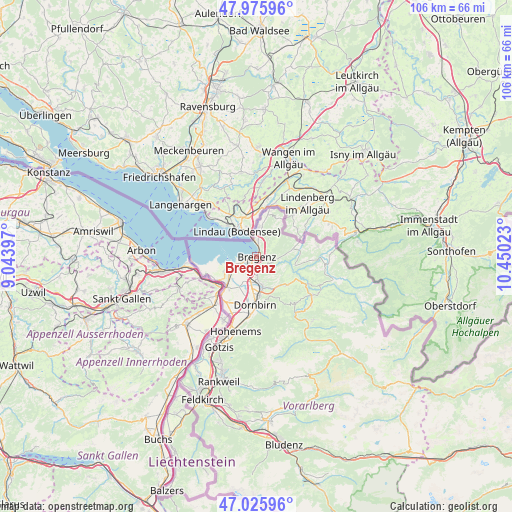
Bregenz GPS coordinates[2]
47° 30' 11.196" North, 9° 44' 49.56" East
| Map corner | latitude | longitude |
|---|---|---|
| Upper-left | 47.97596°, | 9.04397° |
| Center: | 47.50311°, | 9.7471° |
| Lower-right: | 47.02596°, | 10.45023° |
| Map W x H: | 105.6×105.6 km | = 65.6×65.6mi |
| max Lat: | 48.98333° ⇑53.6% North |
| Bregenz: | 47.50311° |
| min Lat: | ⇓46.4% South 46.48841° |
| min Long | Bregenz | max Long |
| 9.57802° | 9.7471° | 17.1° |
| W 1.3%⇐ | ⇒98.7% E |
Elevation
Elevation of Bregenz is 405 m = 1329 ft, and this is 100.5 m = 330 ft below average elevation for this country.
| Max E: |
2140 m = 7021 ft | 57.1% |
| Avg. | 505.5 m = 1658 ft | |
| Bregenz | 405 m = 1329 ft | |
Min E: |
118 m = 387 ft | 42.9% |
See also: Austria elevation on elevation.city.
Geographical zone
Bregenz is located in North temperate zone (between Tropic of Cancer and the Arctic Circle). Distance of this North polar circle is 2119.3 km =1316.9 mi to North.| Distance of | km | miles | from Bregenz |
|---|---|---|---|
| North Pole | 4725.2 | 2936.1 | to North |
| Arctic Circle | 2119.3 | 1316.9 | to North |
| Tropic Cancer | 2675.9 | 1662.7 | to South |
| Equator | 5281.9 | 3282 | to South |


Nearby cities:
15 places around Bregenz: (largest is in red/bold)
• Alberschwende
8.6 km =5.3 mi,  132°
132°
• Bildstein
6.1 km =3.8 mi,  166°
166°
• Buch
5.9 km =3.7 mi,  109°
109°
• Eichenberg
4.3 km =2.7 mi,  38°
38°
• Fußach
6.9 km =4.3 mi,  247°
247°
• Hard
5.3 km =3.3 mi, 245°
• Hohenweiler
9.3 km =5.8 mi,  16°
16°
• Hörbranz
5.2 km =3.2 mi,  2°
2°
• Kennelbach
2.7 km =1.7 mi,  146°
146°
• Langen
5.4 km =3.4 mi,  73°
73°
• Lauterach
3.3 km =2.1 mi,  203°
203°
• Lochau
3.4 km =2.1 mi, 3°
• Möggers
8.8 km =5.5 mi, 36°
• Schwarzach
6.1 km =3.8 mi, 169°
• Wolfurt
4.1 km =2.5 mi,  176°
176°
Sources, notices
• [Note1] Compared only with cities in Austria existing in our database
• [Src1] Map data: © OpenStreetMap contributors (CC-BY-SA)
• [Src2] Other city data from geonames.org with taken over terms of usage.
• [Src3] Geographical zone / Annual Mean Temperature by Robert A. Rohde @ Wikipedia
