Andau geodata
Andau (Burgenland) is a seat of a third-order administrative division; located in Austria in Europe/Vienna (GMT+2) time zone. With population of 2,285 people, there are 531 cities with bigger population in this country. Compared to other cities in Austria, 56.2% of cities are located further ↓South; 99.8% of cities are located further ←West and 100% of cities have higher elevation than Andau. Note1
Administrative division(s):
- Level 1: Burgenland
- Level 2: Politischer Bezirk Neusiedl am See
- Level 3: Andau


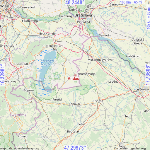
Andau GPS coordinates[2]
47° 46' 27.876" North, 17° 1' 58.548" East
| Map corner | latitude | longitude |
|---|---|---|
| Upper-left | 48.2448°, | 16.32981° |
| Center: | 47.77441°, | 17.03293° |
| Lower-right: | 47.29973°, | 17.73606° |
| Map W x H: | 105.1×105.1 km | = 65.3×65.3mi |
| max Lat: | 48.98333° ⇑43.8% North |
| Andau: | 47.77441° |
| min Lat: | ⇓56.2% South 46.48841° |
| min Long | Andau | max Long |
| 9.57802° | 17.03293° | 17.1° |
| W 99.8%⇐ | ⇒0.2% E |
Elevation
Elevation of Andau is 118 m = 387 ft, and this is 387.5 m = 1271 ft below average elevation for this country.
| Max E: |
2140 m = 7021 ft | 100% |
| Avg. | 505.5 m = 1658 ft | |
| Andau | 118 m = 387 ft | |
Min E: |
118 m = 387 ft | 0% |
See also: Austria elevation on elevation.city.
Geographical zone
Andau is located in North temperate zone (between Tropic of Cancer and the Arctic Circle). Distance of this North polar circle is 2089.2 km =1298.2 mi to North.| Distance of | km | miles | from Andau |
|---|---|---|---|
| North Pole | 4695 | 2917.3 | to North |
| Arctic Circle | 2089.2 | 1298.2 | to North |
| Tropic Cancer | 2706.1 | 1681.5 | to South |
| Equator | 5312 | 3300.7 | to South |


Nearby cities:
15 places around Andau: (largest is in red/bold)
• Apetlon
15.5 km =9.6 mi,  257°
257°
• Frauenkirchen
10.6 km =6.6 mi,  310°
310°
• Gols
16.4 km =10.2 mi,  326°
326°
• Halbturn
11.5 km =7.1 mi,  338°
338°
• Illmitz
17.4 km =10.8 mi,  265°
265°
• Mönchhof
13.6 km =8.5 mi, 329°
• Neusiedl am See
24.1 km =15 mi,  323°
323°
• Nickelsdorf
18.7 km =11.6 mi,  8°
8°
• Pamhagen
12.4 km =7.7 mi,  228°
228°
• Podersdorf am See
17.1 km =10.6 mi,  301°
301°
• Sankt Andrä am Zicksee
6.9 km =4.3 mi,  279°
279°
• Tadten
3.8 km =2.4 mi, 256°
• Wallern im Burgenland
8.8 km =5.5 mi, 234°
• Weiden am See
20.8 km =12.9 mi, 323°
• Zurndorf
23.3 km =14.5 mi,  354°
354°
Sources, notices
• [Note1] Compared only with cities in Austria existing in our database
• [Src1] Map data: © OpenStreetMap contributors (CC-BY-SA)
• [Src2] Other city data from geonames.org with taken over terms of usage.
• [Src3] Geographical zone / Annual Mean Temperature by Robert A. Rohde @ Wikipedia
