Aistersheim geodata
Aistersheim (Upper Austria) is a seat of a third-order administrative division; located in Austria in Europe/Vienna (GMT+2) time zone. With population of 407 people, there are 2612 cities with bigger population in this country. Compared to other cities in Austria, 78.4% of cities are located further ↓South; 70.6% of cities are located further →East and 52.6% of cities have higher elevation than Aistersheim. Note1
Administrative division(s):
- Level 1: Upper Austria
- Level 2: Politischer Bezirk Grieskirchen
- Level 3: Aistersheim


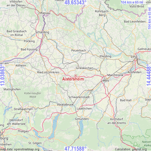
Aistersheim GPS coordinates[2]
48° 11' 12.48" North, 13° 44' 30.3" East
| Map corner | latitude | longitude |
|---|---|---|
| Upper-left | 48.65343°, | 13.03863° |
| Center: | 48.1868°, | 13.74175° |
| Lower-right: | 47.71588°, | 14.44488° |
| Map W x H: | 104.2×104.2 km | = 64.7×64.7mi |
| max Lat: | 48.98333° ⇑21.6% North |
| Aistersheim: | 48.1868° |
| min Lat: | ⇓78.4% South 46.48841° |
| min Long | Aistersheim | max Long |
| 9.57802° | 13.74175° | 17.1° |
| W 29.4%⇐ | ⇒70.6% E |
Elevation
Elevation of Aistersheim is 436 m = 1430 ft, and this is 69.5 m = 228 ft below average elevation for this country.
| Max E: |
2140 m = 7021 ft | 52.6% |
| Avg. | 505.5 m = 1658 ft | |
| Aistersheim | 436 m = 1430 ft | |
Min E: |
118 m = 387 ft | 47.4% |
See also: Austria elevation on elevation.city.
Geographical zone
Aistersheim is located in North temperate zone (between Tropic of Cancer and the Arctic Circle). Distance of this North polar circle is 2043.3 km =1269.6 mi to North.| Distance of | km | miles | from Aistersheim |
|---|---|---|---|
| North Pole | 4649.2 | 2888.9 | to North |
| Arctic Circle | 2043.3 | 1269.6 | to North |
| Tropic Cancer | 2752 | 1710 | to South |
| Equator | 5357.9 | 3329.2 | to South |


Nearby cities:
15 places around Aistersheim: (largest is in red/bold)
• Altenhof am Hausruck
7.4 km =4.6 mi,  216°
216°
• Bachmanning
7.3 km =4.5 mi,  147°
147°
• Gallspach
5.7 km =3.5 mi,  62°
62°
• Gaspoltshofen
4.9 km =3 mi,  184°
184°
• Geboltskirchen
8.8 km =5.5 mi,  245°
245°
• Grieskirchen
8.5 km =5.3 mi,  52°
52°
• Haag am Hausruck
7.3 km =4.5 mi,  267°
267°
• Hofkirchen an der Trattnach
3.7 km =2.3 mi,  357°
357°
• Kematen am Innbach
8.7 km =5.4 mi,  97°
97°
• Meggenhofen
4.1 km =2.5 mi, 100°
• Offenhausen
7.9 km =4.9 mi,  121°
121°
• Taufkirchen an der Trattnach
6.7 km =4.2 mi,  3°
3°
• Tolleterau
6 km =3.7 mi,  30°
30°
• Weibern
3.1 km =1.9 mi,  262°
262°
• Wendling
7.5 km =4.7 mi,  311°
311°
Sources, notices
• [Note1] Compared only with cities in Austria existing in our database
• [Src1] Map data: © OpenStreetMap contributors (CC-BY-SA)
• [Src2] Other city data from geonames.org with taken over terms of usage.
• [Src3] Geographical zone / Annual Mean Temperature by Robert A. Rohde @ Wikipedia
