Gaspoltshofen geodata
Gaspoltshofen (Upper Austria) is a populated place; located in Austria in Europe/Vienna (GMT+2) time zone. With population of 1,313 people, there are 963 cities with bigger population in this country. Compared to other cities in Austria, 75.1% of cities are located further ↓South; 70.7% of cities are located further →East and 50.2% of cities have lower elevation than Gaspoltshofen. Note1
Administrative division(s):
- Level 1: Upper Austria
- Level 2: Politischer Bezirk Grieskirchen
- Level 3: Gaspoltshofen


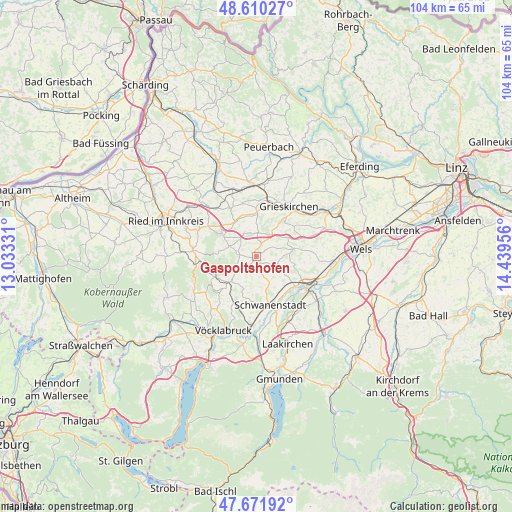
Gaspoltshofen GPS coordinates[2]
48° 8' 35.664" North, 13° 44' 11.148" East
| Map corner | latitude | longitude |
|---|---|---|
| Upper-left | 48.61027°, | 13.03331° |
| Center: | 48.14324°, | 13.73643° |
| Lower-right: | 47.67192°, | 14.43956° |
| Map W x H: | 104.3×104.3 km | = 64.8×64.8mi |
| max Lat: | 48.98333° ⇑24.9% North |
| Gaspoltshofen: | 48.14324° |
| min Lat: | ⇓75.1% South 46.48841° |
| min Long | Gaspoltshofen | max Long |
| 9.57802° | 13.73643° | 17.1° |
| W 29.3%⇐ | ⇒70.7% E |
Elevation
Elevation of Gaspoltshofen is 451 m = 1480 ft, and this is 54.5 m = 179 ft below average elevation for this country.
| Max E: |
2140 m = 7021 ft | 49.8% |
| Avg. | 505.5 m = 1658 ft | |
| Gaspoltshofen | 451 m = 1480 ft | |
Min E: |
118 m = 387 ft | 50.2% |
See also: Austria elevation on elevation.city.
Geographical zone
Gaspoltshofen is located in North temperate zone (between Tropic of Cancer and the Arctic Circle). Distance of this North polar circle is 2048.1 km =1272.6 mi to North.| Distance of | km | miles | from Gaspoltshofen |
|---|---|---|---|
| North Pole | 4654 | 2891.9 | to North |
| Arctic Circle | 2048.1 | 1272.6 | to North |
| Tropic Cancer | 2747.1 | 1707 | to South |
| Equator | 5353 | 3326.2 | to South |


Nearby cities:
15 places around Gaspoltshofen: (largest is in red/bold)
• Aichkirchen
5.6 km =3.5 mi,  132°
132°
• Aistersheim
4.9 km =3 mi,  4°
4°
• Altenhof am Hausruck
4.1 km =2.5 mi,  254°
254°
• Atzbach
7.1 km =4.4 mi,  200°
200°
• Bachmanning
4.5 km =2.8 mi,  107°
107°
• Geboltskirchen
7.7 km =4.8 mi,  278°
278°
• Manning
8 km =5 mi,  220°
220°
• Meggenhofen
6 km =3.7 mi,  47°
47°
• Neukirchen bei Lambach
7.7 km =4.8 mi, 128°
• Niederthalheim
5.5 km =3.4 mi,  154°
154°
• Offenhausen
7.2 km =4.5 mi,  84°
84°
• Ottnang am Hausruck
7.8 km =4.8 mi,  227°
227°
• Pitzenberg
7.8 km =4.8 mi,  186°
186°
• Weibern
5.2 km =3.2 mi,  328°
328°
• Wolfsegg am Hausruck
6.2 km =3.9 mi, 229°
Sources, notices
• [Note1] Compared only with cities in Austria existing in our database
• [Src1] Map data: © OpenStreetMap contributors (CC-BY-SA)
• [Src2] Other city data from geonames.org with taken over terms of usage.
• [Src3] Geographical zone / Annual Mean Temperature by Robert A. Rohde @ Wikipedia
