Abtenau geodata
Abtenau (Salzburg) is a seat of a third-order administrative division; located in Austria in Europe/Vienna (GMT+2) time zone. With population of 1,188 people, there are 1057 cities with bigger population in this country. Compared to other cities in Austria, 51.1% of cities are located further ↑North; 77.3% of cities are located further →East and 80% of cities have lower elevation than Abtenau. Note1


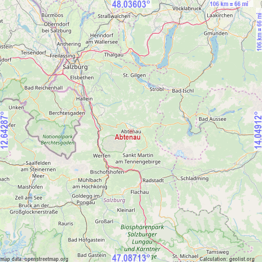
Abtenau GPS coordinates[2]
47° 33' 49.428" North, 13° 20' 45.564" East
| Map corner | latitude | longitude |
|---|---|---|
| Upper-left | 48.03603°, | 12.64287° |
| Center: | 47.56373°, | 13.34599° |
| Lower-right: | 47.08713°, | 14.04912° |
| Map W x H: | 105.5×105.5 km | = 65.6×65.6mi |
| max Lat: | 48.98333° ⇑51.1% North |
| Abtenau: | 47.56373° |
| min Lat: | ⇓48.9% South 46.48841° |
| min Long | Abtenau | max Long |
| 9.57802° | 13.34599° | 17.1° |
| W 22.7%⇐ | ⇒77.3% E |
Elevation
Elevation of Abtenau is 717 m = 2352 ft, and this is 211.5 m = 694 ft above average elevation for this country.
| Max E: |
2140 m = 7021 ft | 20% |
| Abtenau | 717 m 2352 ft | |
| Avg. | 505.5 m = 1658 ft | |
Min E: |
118 m = 387 ft | 80% |
See also: Austria elevation on elevation.city.
Geographical zone
Abtenau is located in North temperate zone (between Tropic of Cancer and the Arctic Circle). Distance of this North polar circle is 2112.6 km =1312.7 mi to North.| Distance of | km | miles | from Abtenau |
|---|---|---|---|
| North Pole | 4718.5 | 2931.9 | to North |
| Arctic Circle | 2112.6 | 1312.7 | to North |
| Tropic Cancer | 2682.7 | 1667 | to South |
| Equator | 5288.6 | 3286.2 | to South |


Nearby cities:
15 places around Abtenau: (largest is in red/bold)
• Annaberg im Lammertal
8.4 km =5.2 mi,  130°
130°
• Au
0.9 km =0.6 mi,  210°
210°
• Golling an der Salzach
14 km =8.7 mi,  286°
286°
• Gosau
14.3 km =8.9 mi,  80°
80°
• Kellau
13.4 km =8.3 mi, 291°
• Lammertal
7.6 km =4.7 mi,  168°
168°
• Neubach
9 km =5.6 mi,  150°
150°
• Obergäu
13.1 km =8.1 mi,  282°
282°
• Oberlangenberg
14.3 km =8.9 mi,  304°
304°
• Scheffau am Tennengebirge
9.8 km =6.1 mi, 286°
• St. Martin of Tennengebirge
11.2 km =7 mi, 167°
• Sulzau
15.2 km =9.4 mi,  242°
242°
• Taugl
14.2 km =8.8 mi,  310°
310°
• Werfen
15.2 km =9.4 mi,  230°
230°
• Werfenweng
13.2 km =8.2 mi, 210°
Sources, notices
• [Note1] Compared only with cities in Austria existing in our database
• [Src1] Map data: © OpenStreetMap contributors (CC-BY-SA)
• [Src2] Other city data from geonames.org with taken over terms of usage.
• [Src3] Geographical zone / Annual Mean Temperature by Robert A. Rohde @ Wikipedia
