Lammertal geodata
Lammertal (Salzburg) is a populated place; located in Austria in Europe/Vienna (GMT+2) time zone. With population of 583 people, there are 2196 cities with bigger population in this country. Compared to other cities in Austria, 53.9% of cities are located further ↑North; 77% of cities are located further →East and 92% of cities have lower elevation than Lammertal. Note1
Administrative division(s):
- Level 1: Salzburg
- Level 2: Politischer Bezirk Sankt Johann im Pongau
- Level 3: Sankt Martin am Tennengebirge


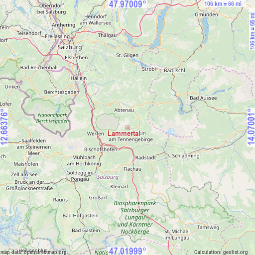
Lammertal GPS coordinates[2]
47° 29' 49.884" North, 13° 22' 0.768" East
| Map corner | latitude | longitude |
|---|---|---|
| Upper-left | 47.97009°, | 12.66376° |
| Center: | 47.49719°, | 13.36688° |
| Lower-right: | 47.01999°, | 14.07001° |
| Map W x H: | 105.6×105.6 km | = 65.6×65.6mi |
| max Lat: | 48.98333° ⇑53.9% North |
| Lammertal: | 47.49719° |
| min Lat: | ⇓46.1% South 46.48841° |
| min Long | Lammertal | max Long |
| 9.57802° | 13.36688° | 17.1° |
| W 23%⇐ | ⇒77% E |
Elevation
Elevation of Lammertal is 926 m = 3038 ft, and this is 420.5 m = 1380 ft above average elevation for this country.
| Max E: |
2140 m = 7021 ft | 8% |
| Lammertal | 926 m 3038 ft | |
| Avg. | 505.5 m = 1658 ft | |
Min E: |
118 m = 387 ft | 92% |
See also: Austria elevation on elevation.city.
Geographical zone
Lammertal is located in North temperate zone (between Tropic of Cancer and the Arctic Circle). Distance of this North polar circle is 2120 km =1317.3 mi to North.| Distance of | km | miles | from Lammertal |
|---|---|---|---|
| North Pole | 4725.9 | 2936.5 | to North |
| Arctic Circle | 2120 | 1317.3 | to North |
| Tropic Cancer | 2675.3 | 1662.4 | to South |
| Equator | 5281.2 | 3281.6 | to South |


Nearby cities:
15 places around Lammertal: (largest is in red/bold)
• Abtenau
7.6 km =4.7 mi,  348°
348°
• Altenmarkt im Pongau
13.2 km =8.2 mi,  163°
163°
• Annaberg im Lammertal
5.2 km =3.2 mi,  68°
68°
• Au
7 km =4.3 mi,  343°
343°
• Dorfwerfen
12.8 km =8 mi,  250°
250°
• Eben im Pongau
11.1 km =6.9 mi,  167°
167°
• Filzmoos
13.3 km =8.3 mi,  122°
122°
• Hüttau
10.1 km =6.3 mi,  206°
206°
• Neubach
2.9 km =1.8 mi,  98°
98°
• Neuberg
10.2 km =6.3 mi, 120°
• Pfarrwerfen
12.9 km =8 mi, 249°
• Sonnberg
9.7 km =6 mi,  202°
202°
• St. Martin of Tennengebirge
3.7 km =2.3 mi, 167°
• Werfen
13.5 km =8.4 mi,  259°
259°
• Werfenweng
9.2 km =5.7 mi,  244°
244°
Sources, notices
• [Note1] Compared only with cities in Austria existing in our database
• [Src1] Map data: © OpenStreetMap contributors (CC-BY-SA)
• [Src2] Other city data from geonames.org with taken over terms of usage.
• [Src3] Geographical zone / Annual Mean Temperature by Robert A. Rohde @ Wikipedia
