Gosau geodata
Gosau (Upper Austria) is a populated place; located in Austria in Europe/Vienna (GMT+2) time zone. With population of 1,792 people, there are 694 cities with bigger population in this country. Compared to other cities in Austria, 50.1% of cities are located further ↑North; 74.4% of cities are located further →East and 81.1% of cities have lower elevation than Gosau. Note1
Administrative division(s):
- Level 1: Upper Austria
- Level 2: Politischer Bezirk Gmunden
- Level 3: Gosau


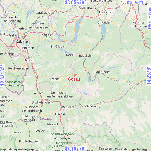
Gosau GPS coordinates[2]
47° 35' 3.012" North, 13° 32' 4.092" East
| Map corner | latitude | longitude |
|---|---|---|
| Upper-left | 48.05629°, | 12.83135° |
| Center: | 47.58417°, | 13.53447° |
| Lower-right: | 47.10776°, | 14.2376° |
| Map W x H: | 105.5×105.5 km | = 65.6×65.6mi |
| max Lat: | 48.98333° ⇑50.1% North |
| Gosau: | 47.58417° |
| min Lat: | ⇓49.9% South 46.48841° |
| min Long | Gosau | max Long |
| 9.57802° | 13.53447° | 17.1° |
| W 25.6%⇐ | ⇒74.4% E |
Elevation
Elevation of Gosau is 738 m = 2421 ft, and this is 232.5 m = 763 ft above average elevation for this country.
| Max E: |
2140 m = 7021 ft | 18.9% |
| Gosau | 738 m 2421 ft | |
| Avg. | 505.5 m = 1658 ft | |
Min E: |
118 m = 387 ft | 81.1% |
See also: Austria elevation on elevation.city.
Geographical zone
Gosau is located in North temperate zone (between Tropic of Cancer and the Arctic Circle). Distance of this North polar circle is 2110.3 km =1311.3 mi to North.| Distance of | km | miles | from Gosau |
|---|---|---|---|
| North Pole | 4716.2 | 2930.5 | to North |
| Arctic Circle | 2110.3 | 1311.3 | to North |
| Tropic Cancer | 2684.9 | 1668.3 | to South |
| Equator | 5290.9 | 3287.6 | to South |


Nearby cities:
15 places around Gosau: (largest is in red/bold)
• Abtenau
14.3 km =8.9 mi,  260°
260°
• Ahorn
15.1 km =9.4 mi,  19°
19°
• Aigen
12.9 km =8 mi,  359°
359°
• Annaberg im Lammertal
10.9 km =6.8 mi,  224°
224°
• Au
14.9 km =9.3 mi, 258°
• Bad Goisern
8.9 km =5.5 mi,  43°
43°
• Gschwandt
8.2 km =5.1 mi,  49°
49°
• Haiden
15.1 km =9.4 mi,  9°
9°
• Kaltenbach
14.7 km =9.1 mi, 22°
• Neubach
14 km =8.7 mi, 223°
• Obertraun
11.8 km =7.3 mi,  104°
104°
• Reiterndorf
15.1 km =9.4 mi,  28°
28°
• Sulzbach
13.9 km =8.6 mi, 27°
• Untersee
9.4 km =5.8 mi,  67°
67°
• Weissenbach
13.1 km =8.1 mi,  348°
348°
Sources, notices
• [Note1] Compared only with cities in Austria existing in our database
• [Src1] Map data: © OpenStreetMap contributors (CC-BY-SA)
• [Src2] Other city data from geonames.org with taken over terms of usage.
• [Src3] Geographical zone / Annual Mean Temperature by Robert A. Rohde @ Wikipedia
