Sellrain geodata
Sellrain (Tyrol) is a seat of a third-order administrative division; located in Austria in Europe/Vienna (GMT+2) time zone. With population of 1,333 people, there are 950 cities with bigger population in this country. Compared to other cities in Austria, 71.6% of cities are located further ↑North; 93% of cities are located further →East and 92.8% of cities have lower elevation than Sellrain. Note1
Administrative division(s):
- Level 1: Tyrol
- Level 2: Politischer Bezirk Innsbruck Land
- Level 3: Sellrain


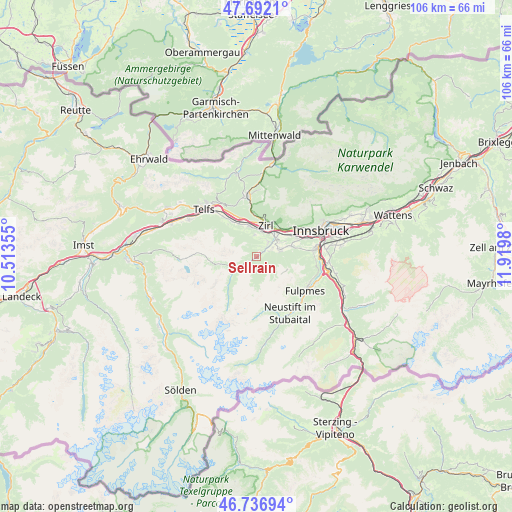
Sellrain GPS coordinates[2]
47° 13' 0.012" North, 11° 13' 0.012" East
| Map corner | latitude | longitude |
|---|---|---|
| Upper-left | 47.6921°, | 10.51355° |
| Center: | 47.21667°, | 11.21667° |
| Lower-right: | 46.73694°, | 11.9198° |
| Map W x H: | 106.2×106.2 km | = 66×66mi |
| max Lat: | 48.98333° ⇑71.6% North |
| Sellrain: | 47.21667° |
| min Lat: | ⇓28.4% South 46.48841° |
| min Long | Sellrain | max Long |
| 9.57802° | 11.21667° | 17.1° |
| W 7%⇐ | ⇒93% E |
Elevation
Elevation of Sellrain is 954 m = 3130 ft, and this is 448.5 m = 1471 ft above average elevation for this country.
| Max E: |
2140 m = 7021 ft | 7.2% |
| Sellrain | 954 m 3130 ft | |
| Avg. | 505.5 m = 1658 ft | |
Min E: |
118 m = 387 ft | 92.8% |
See also: Austria elevation on elevation.city.
Geographical zone
Sellrain is located in North temperate zone (between Tropic of Cancer and the Arctic Circle). Distance of this North polar circle is 2151.2 km =1336.7 mi to North.| Distance of | km | miles | from Sellrain |
|---|---|---|---|
| North Pole | 4757.1 | 2955.9 | to North |
| Arctic Circle | 2151.2 | 1336.7 | to North |
| Tropic Cancer | 2644.1 | 1643 | to South |
| Equator | 5250 | 3262.2 | to South |


Nearby cities:
15 places around Sellrain: (largest is in red/bold)
• Axams
5 km =3.1 mi,  71°
71°
• Birgitz
6.6 km =4.1 mi, 71°
• Gries im Sellrain
5.1 km =3.2 mi,  242°
242°
• Grinzens
3.1 km =1.9 mi,  63°
63°
• Götzens
7.5 km =4.7 mi, 73°
• Hatting
7.8 km =4.8 mi,  332°
332°
• Inzing
6.5 km =4 mi,  347°
347°
• Kematen in Tirol
5.3 km =3.3 mi,  45°
45°
• Kristen
6.3 km =3.9 mi, 61°
• Oberperfuss
3.9 km =2.4 mi,  36°
36°
• Pettnau
9.4 km =5.8 mi, 332°
• Polling in Tirol
9 km =5.6 mi, 325°
• Ranggen
4.5 km =2.8 mi, 354°
• Unterperfuss
6.1 km =3.8 mi,  24°
24°
• Zirl
6.6 km =4.1 mi, 15°
Sources, notices
• [Note1] Compared only with cities in Austria existing in our database
• [Src1] Map data: © OpenStreetMap contributors (CC-BY-SA)
• [Src2] Other city data from geonames.org with taken over terms of usage.
• [Src3] Geographical zone / Annual Mean Temperature by Robert A. Rohde @ Wikipedia
