Oberperfuss geodata
Oberperfuss (Tyrol) is a seat of a third-order administrative division; located in Austria in Europe/Vienna (GMT+2) time zone. With population of 3,043 people, there are 372 cities with bigger population in this country. Compared to other cities in Austria, 69.6% of cities are located further ↑North; 92.9% of cities are located further →East and 86% of cities have lower elevation than Oberperfuss. Note1
Administrative division(s):
- Level 1: Tyrol
- Level 2: Politischer Bezirk Innsbruck Land
- Level 3: Oberperfuss


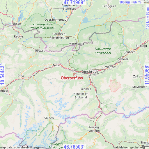
Oberperfuss GPS coordinates[2]
47° 14' 40.236" North, 11° 14' 51.18" East
| Map corner | latitude | longitude |
|---|---|---|
| Upper-left | 47.71969°, | 10.54443° |
| Center: | 47.24451°, | 11.24755° |
| Lower-right: | 46.76503°, | 11.95068° |
| Map W x H: | 106.1×106.1 km | = 65.9×65.9mi |
| max Lat: | 48.98333° ⇑69.6% North |
| Oberperfuss: | 47.24451° |
| min Lat: | ⇓30.4% South 46.48841° |
| min Long | Oberperfuss | max Long |
| 9.57802° | 11.24755° | 17.1° |
| W 7.1%⇐ | ⇒92.9% E |
Elevation
Elevation of Oberperfuss is 812 m = 2664 ft, and this is 306.5 m = 1006 ft above average elevation for this country.
| Max E: |
2140 m = 7021 ft | 14% |
| Oberperfuss | 812 m 2664 ft | |
| Avg. | 505.5 m = 1658 ft | |
Min E: |
118 m = 387 ft | 86% |
See also: Austria elevation on elevation.city.
Geographical zone
Oberperfuss is located in North temperate zone (between Tropic of Cancer and the Arctic Circle). Distance of this North polar circle is 2148.1 km =1334.8 mi to North.| Distance of | km | miles | from Oberperfuss |
|---|---|---|---|
| North Pole | 4754 | 2954 | to North |
| Arctic Circle | 2148.1 | 1334.8 | to North |
| Tropic Cancer | 2647.2 | 1644.9 | to South |
| Equator | 5253.1 | 3264.1 | to South |


Nearby cities:
15 places around Oberperfuss: (largest is in red/bold)
• Axams
2.8 km =1.7 mi,  122°
122°
• Birgitz
4 km =2.5 mi,  104°
104°
• Grinzens
1.7 km =1.1 mi,  165°
165°
• Götzens
4.9 km =3 mi, 101°
• Hatting
7.1 km =4.4 mi,  302°
302°
• Inzing
5 km =3.1 mi,  310°
310°
• Kematen in Tirol
1.6 km =1 mi,  67°
67°
• Kristen
3.2 km =2 mi,  92°
92°
• Polling in Tirol
8.5 km =5.3 mi, 300°
• Ranggen
3.1 km =1.9 mi, 297°
• Reith bei Seefeld
7.1 km =4.4 mi,  329°
329°
• Sellrain
3.9 km =2.4 mi,  216°
216°
• Unterperfuss
2.5 km =1.6 mi,  4°
4°
• Völs
6.5 km =4 mi,  84°
84°
• Zirl
3.3 km =2.1 mi,  349°
349°
Sources, notices
• [Note1] Compared only with cities in Austria existing in our database
• [Src1] Map data: © OpenStreetMap contributors (CC-BY-SA)
• [Src2] Other city data from geonames.org with taken over terms of usage.
• [Src3] Geographical zone / Annual Mean Temperature by Robert A. Rohde @ Wikipedia
