Inzing geodata
Inzing (Tyrol) is a seat of a third-order administrative division; located in Austria in Europe/Vienna (GMT+2) time zone. With population of 3,566 people, there are 301 cities with bigger population in this country. Compared to other cities in Austria, 67.7% of cities are located further ↑North; 93.1% of cities are located further →East and 71.7% of cities have lower elevation than Inzing. Note1
Administrative division(s):
- Level 1: Tyrol
- Level 2: Politischer Bezirk Innsbruck Land
- Level 3: Inzing


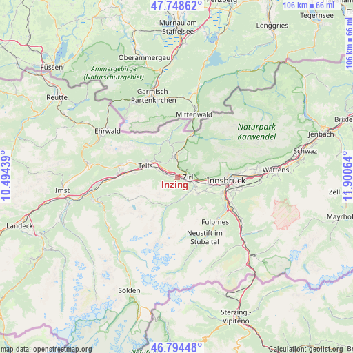
Inzing GPS coordinates[2]
47° 16' 25.32" North, 11° 11' 51.036" East
| Map corner | latitude | longitude |
|---|---|---|
| Upper-left | 47.74862°, | 10.49439° |
| Center: | 47.2737°, | 11.19751° |
| Lower-right: | 46.79448°, | 11.90064° |
| Map W x H: | 106.1×106.1 km | = 65.9×65.9mi |
| max Lat: | 48.98333° ⇑67.7% North |
| Inzing: | 47.2737° |
| min Lat: | ⇓32.3% South 46.48841° |
| min Long | Inzing | max Long |
| 9.57802° | 11.19751° | 17.1° |
| W 6.9%⇐ | ⇒93.1% E |
Elevation
Elevation of Inzing is 609 m = 1998 ft, and this is 103.5 m = 340 ft above average elevation for this country.
| Max E: |
2140 m = 7021 ft | 28.3% |
| Inzing | 609 m 1998 ft | |
| Avg. | 505.5 m = 1658 ft | |
Min E: |
118 m = 387 ft | 71.7% |
See also: Austria elevation on elevation.city.
Geographical zone
Inzing is located in North temperate zone (between Tropic of Cancer and the Arctic Circle). Distance of this North polar circle is 2144.8 km =1332.7 mi to North.| Distance of | km | miles | from Inzing |
|---|---|---|---|
| North Pole | 4750.7 | 2951.9 | to North |
| Arctic Circle | 2144.8 | 1332.7 | to North |
| Tropic Cancer | 2650.4 | 1646.9 | to South |
| Equator | 5256.3 | 3266.1 | to South |


Nearby cities:
15 places around Inzing: (largest is in red/bold)
• Axams
7.8 km =4.8 mi,  127°
127°
• Flaurling
5.9 km =3.7 mi,  289°
289°
• Grinzens
6.5 km =4 mi,  139°
139°
• Hatting
2.3 km =1.4 mi,  284°
284°
• Kematen in Tirol
5.8 km =3.6 mi,  116°
116°
• Kristen
7.7 km =4.8 mi, 115°
• Oberperfuss
5 km =3.1 mi, 130°
• Pettnau
3.5 km =2.2 mi,  305°
305°
• Polling in Tirol
3.7 km =2.3 mi, 286°
• Ranggen
2.1 km =1.3 mi,  150°
150°
• Reith bei Seefeld
2.9 km =1.8 mi,  3°
3°
• Seefeld in Tirol
6.3 km =3.9 mi,  353°
353°
• Sellrain
6.5 km =4 mi,  167°
167°
• Unterperfuss
4 km =2.5 mi,  101°
101°
• Zirl
3.2 km =2 mi,  89°
89°
Sources, notices
• [Note1] Compared only with cities in Austria existing in our database
• [Src1] Map data: © OpenStreetMap contributors (CC-BY-SA)
• [Src2] Other city data from geonames.org with taken over terms of usage.
• [Src3] Geographical zone / Annual Mean Temperature by Robert A. Rohde @ Wikipedia
