Hatting geodata
Hatting (Tyrol) is a seat of a third-order administrative division; located in Austria in Europe/Vienna (GMT+2) time zone. With population of 1,368 people, there are 920 cities with bigger population in this country. Compared to other cities in Austria, 67.5% of cities are located further ↑North; 93.2% of cities are located further →East and 72% of cities have lower elevation than Hatting. Note1
Administrative division(s):
- Level 1: Tyrol
- Level 2: Politischer Bezirk Innsbruck Land
- Level 3: Hatting


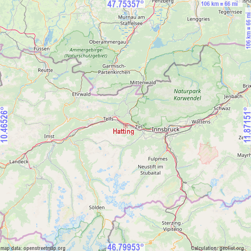
Hatting GPS coordinates[2]
47° 16' 43.32" North, 11° 10' 6.168" East
| Map corner | latitude | longitude |
|---|---|---|
| Upper-left | 47.75357°, | 10.46526° |
| Center: | 47.2787°, | 11.16838° |
| Lower-right: | 46.79953°, | 11.87151° |
| Map W x H: | 106.1×106.1 km | = 65.9×65.9mi |
| max Lat: | 48.98333° ⇑67.5% North |
| Hatting: | 47.2787° |
| min Lat: | ⇓32.5% South 46.48841° |
| min Long | Hatting | max Long |
| 9.57802° | 11.16838° | 17.1° |
| W 6.8%⇐ | ⇒93.2% E |
Elevation
Elevation of Hatting is 611 m = 2005 ft, and this is 105.5 m = 346 ft above average elevation for this country.
| Max E: |
2140 m = 7021 ft | 28% |
| Hatting | 611 m 2005 ft | |
| Avg. | 505.5 m = 1658 ft | |
Min E: |
118 m = 387 ft | 72% |
See also: Austria elevation on elevation.city.
Geographical zone
Hatting is located in North temperate zone (between Tropic of Cancer and the Arctic Circle). Distance of this North polar circle is 2144.3 km =1332.4 mi to North.| Distance of | km | miles | from Hatting |
|---|---|---|---|
| North Pole | 4750.2 | 2951.6 | to North |
| Arctic Circle | 2144.3 | 1332.4 | to North |
| Tropic Cancer | 2651 | 1647.3 | to South |
| Equator | 5256.9 | 3266.5 | to South |


Nearby cities:
15 places around Hatting: (largest is in red/bold)
• Flaurling
3.7 km =2.3 mi,  292°
292°
• Inzing
2.3 km =1.4 mi,  104°
104°
• Kematen in Tirol
8.1 km =5 mi,  113°
113°
• Oberhofen im Inntal
6.8 km =4.2 mi, 290°
• Oberperfuss
7.1 km =4.4 mi,  122°
122°
• Pettnau
1.6 km =1 mi,  335°
335°
• Pfaffenhofen
6.8 km =4.2 mi, 290°
• Polling in Tirol
1.5 km =0.9 mi, 290°
• Ranggen
4 km =2.5 mi,  126°
126°
• Reith bei Seefeld
3.4 km =2.1 mi,  45°
45°
• Seefeld in Tirol
5.9 km =3.7 mi,  14°
14°
• Sellrain
7.8 km =4.8 mi,  152°
152°
• Telfs
8.2 km =5.1 mi, 292°
• Unterperfuss
6.3 km =3.9 mi, 102°
• Zirl
5.4 km =3.4 mi, 95°
Sources, notices
• [Note1] Compared only with cities in Austria existing in our database
• [Src1] Map data: © OpenStreetMap contributors (CC-BY-SA)
• [Src2] Other city data from geonames.org with taken over terms of usage.
• [Src3] Geographical zone / Annual Mean Temperature by Robert A. Rohde @ Wikipedia
