Dietenberg geodata
Dietenberg (Styria) is a populated place; located in Austria in Europe/Vienna (GMT+2) time zone. With population of 700 people, there are 1854 cities with bigger population in this country. Compared to other cities in Austria, 84.5% of cities are located further ↑North; 58.1% of cities are located further ←West and 55% of cities have higher elevation than Dietenberg. Note1


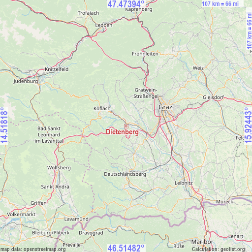
Dietenberg GPS coordinates[2]
46° 59' 47.508" North, 15° 13' 16.68" East
| Map corner | latitude | longitude |
|---|---|---|
| Upper-left | 47.47394°, | 14.51818° |
| Center: | 46.99653°, | 15.2213° |
| Lower-right: | 46.51482°, | 15.92443° |
| Map W x H: | 106.6×106.6 km | = 66.2×66.2mi |
| max Lat: | 48.98333° ⇑84.5% North |
| Dietenberg: | 46.99653° |
| min Lat: | ⇓15.5% South 46.48841° |
| min Long | Dietenberg | max Long |
| 9.57802° | 15.2213° | 17.1° |
| W 58.1%⇐ | ⇒41.9% E |
Elevation
Elevation of Dietenberg is 420 m = 1378 ft, and this is 85.5 m = 281 ft below average elevation for this country.
| Max E: |
2140 m = 7021 ft | 55% |
| Avg. | 505.5 m = 1658 ft | |
| Dietenberg | 420 m = 1378 ft | |
Min E: |
118 m = 387 ft | 45% |
See also: Austria elevation on elevation.city.
Geographical zone
Dietenberg is located in North temperate zone (between Tropic of Cancer and the Arctic Circle). Distance of this North polar circle is 2175.6 km =1351.9 mi to North.| Distance of | km | miles | from Dietenberg |
|---|---|---|---|
| North Pole | 4781.5 | 2971.1 | to North |
| Arctic Circle | 2175.6 | 1351.9 | to North |
| Tropic Cancer | 2619.6 | 1627.7 | to South |
| Equator | 5225.5 | 3247 | to South |


Nearby cities:
15 places around Dietenberg: (largest is in red/bold)
• Grosssöding
6 km =3.7 mi,  86°
86°
• Gundersdorf
5.3 km =3.3 mi,  169°
169°
• Hitzendorf
7.2 km =4.5 mi,  55°
55°
• Kleingaisfeld
3.3 km =2.1 mi,  345°
345°
• Kleinsöding
4.7 km =2.9 mi, 85°
• Krottendorf bei Ligist
2.3 km =1.4 mi, 351°
• Ligist
0.8 km =0.5 mi,  249°
249°
• Mooskirchen
4.7 km =2.9 mi,  110°
110°
• Pichling bei Mooskirchen
4.1 km =2.5 mi, 56°
• Sankt Bartholomä
7.1 km =4.4 mi,  23°
23°
• Schadendorf
7.5 km =4.7 mi,  100°
100°
• Stallhofen
6 km =3.7 mi,  356°
356°
• Steinberg bei Ligist
1.5 km =0.9 mi,  193°
193°
• Voitsberg
7.4 km =4.6 mi,  315°
315°
• Zirknitz
6.1 km =3.8 mi,  150°
150°
Sources, notices
• [Note1] Compared only with cities in Austria existing in our database
• [Src1] Map data: © OpenStreetMap contributors (CC-BY-SA)
• [Src2] Other city data from geonames.org with taken over terms of usage.
• [Src3] Geographical zone / Annual Mean Temperature by Robert A. Rohde @ Wikipedia
