Kleingaisfeld geodata
Kleingaisfeld (Styria) is a populated place; located in Austria in Europe/Vienna (GMT+2) time zone. With population of 795 people, there are 1624 cities with bigger population in this country. Compared to other cities in Austria, 83% of cities are located further ↑North; 57.6% of cities are located further ←West and 54.7% of cities have higher elevation than Kleingaisfeld. Note1
Administrative division(s):
- Level 1: Styria
- Level 2: Politischer Bezirk Voitsberg
- Level 3: Krottendorf-Gaisfeld


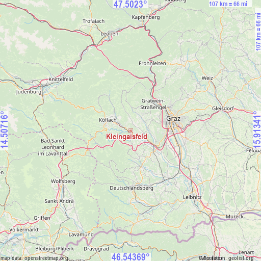
Kleingaisfeld GPS coordinates[2]
47° 1' 30.54" North, 15° 12' 37.008" East
| Map corner | latitude | longitude |
|---|---|---|
| Upper-left | 47.5023°, | 14.50716° |
| Center: | 47.02515°, | 15.21028° |
| Lower-right: | 46.54369°, | 15.91341° |
| Map W x H: | 106.6×106.6 km | = 66.2×66.2mi |
| max Lat: | 48.98333° ⇑83% North |
| Kleingaisfeld: | 47.02515° |
| min Lat: | ⇓17% South 46.48841° |
| min Long | Kleingaisfeld | max Long |
| 9.57802° | 15.21028° | 17.1° |
| W 57.6%⇐ | ⇒42.4% E |
Elevation
Elevation of Kleingaisfeld is 423 m = 1388 ft, and this is 82.5 m = 271 ft below average elevation for this country.
| Max E: |
2140 m = 7021 ft | 54.7% |
| Avg. | 505.5 m = 1658 ft | |
| Kleingaisfeld | 423 m = 1388 ft | |
Min E: |
118 m = 387 ft | 45.3% |
See also: Austria elevation on elevation.city.
Geographical zone
Kleingaisfeld is located in North temperate zone (between Tropic of Cancer and the Arctic Circle). Distance of this North polar circle is 2172.5 km =1349.9 mi to North.| Distance of | km | miles | from Kleingaisfeld |
|---|---|---|---|
| North Pole | 4778.4 | 2969.2 | to North |
| Arctic Circle | 2172.5 | 1349.9 | to North |
| Tropic Cancer | 2622.8 | 1629.7 | to South |
| Equator | 5228.7 | 3249 | to South |


Nearby cities:
15 places around Kleingaisfeld: (largest is in red/bold)
• Dietenberg
3.3 km =2.1 mi,  165°
165°
• Grosssöding
7.4 km =4.6 mi,  112°
112°
• Hitzendorf
6.9 km =4.3 mi,  82°
82°
• Jaritzberg
7.1 km =4.4 mi,  24°
24°
• Kleinsöding
6.2 km =3.9 mi,  116°
116°
• Krottendorf bei Ligist
1.1 km =0.7 mi,  152°
152°
• Ligist
3.5 km =2.2 mi,  179°
179°
• Mooskirchen
7.1 km =4.4 mi,  132°
132°
• Pichling bei Mooskirchen
4.4 km =2.7 mi,  102°
102°
• Rohrbach
6.2 km =3.9 mi,  63°
63°
• Rosental an der Kainach
7.3 km =4.5 mi,  293°
293°
• Sankt Bartholomä
4.9 km =3 mi,  48°
48°
• Stallhofen
2.8 km =1.7 mi,  9°
9°
• Steinberg bei Ligist
4.7 km =2.9 mi, 174°
• Voitsberg
4.8 km =3 mi,  296°
296°
Sources, notices
• [Note1] Compared only with cities in Austria existing in our database
• [Src1] Map data: © OpenStreetMap contributors (CC-BY-SA)
• [Src2] Other city data from geonames.org with taken over terms of usage.
• [Src3] Geographical zone / Annual Mean Temperature by Robert A. Rohde @ Wikipedia
