Dürnau geodata
Dürnau (Upper Austria) is a populated place; located in Austria in Europe/Vienna (GMT+2) time zone. With population of 2,747 people, there are 424 cities with bigger population in this country. Compared to other cities in Austria, 65.9% of cities are located further ↓South; 72.6% of cities are located further →East and 51.7% of cities have higher elevation than Dürnau. Note1
Administrative division(s):
- Level 1: Upper Austria
- Level 2: Politischer Bezirk Vöcklabruck
- Level 3: Vöcklabruck


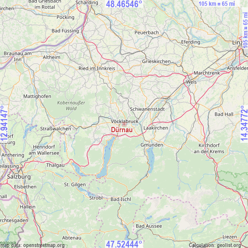
Dürnau GPS coordinates[2]
47° 59' 49.56" North, 13° 38' 40.524" East
| Map corner | latitude | longitude |
|---|---|---|
| Upper-left | 48.46546°, | 12.94147° |
| Center: | 47.9971°, | 13.64459° |
| Lower-right: | 47.52444°, | 14.34772° |
| Map W x H: | 104.6×104.6 km | = 65×65mi |
| max Lat: | 48.98333° ⇑34.1% North |
| Dürnau: | 47.9971° |
| min Lat: | ⇓65.9% South 46.48841° |
| min Long | Dürnau | max Long |
| 9.57802° | 13.64459° | 17.1° |
| W 27.4%⇐ | ⇒72.6% E |
Elevation
Elevation of Dürnau is 440 m = 1444 ft, and this is 65.5 m = 215 ft below average elevation for this country.
| Max E: |
2140 m = 7021 ft | 51.7% |
| Avg. | 505.5 m = 1658 ft | |
| Dürnau | 440 m = 1444 ft | |
Min E: |
118 m = 387 ft | 48.3% |
See also: Austria elevation on elevation.city.
Geographical zone
Dürnau is located in North temperate zone (between Tropic of Cancer and the Arctic Circle). Distance of this North polar circle is 2064.4 km =1282.8 mi to North.| Distance of | km | miles | from Dürnau |
|---|---|---|---|
| North Pole | 4670.3 | 2902 | to North |
| Arctic Circle | 2064.4 | 1282.8 | to North |
| Tropic Cancer | 2730.9 | 1696.9 | to South |
| Equator | 5336.8 | 3316.1 | to South |


Nearby cities:
15 places around Dürnau: (largest is in red/bold)
• Alt Lenzing
3.5 km =2.2 mi,  204°
204°
• Dörfl
1.9 km =1.2 mi,  23°
23°
• Lenzing
3.8 km =2.4 mi,  225°
225°
• Lixlau
1.3 km =0.8 mi,  101°
101°
• Oberstraß
4.9 km =3 mi,  81°
81°
• Pichlwang
2.2 km =1.4 mi,  256°
256°
• Preising
4.7 km =2.9 mi,  92°
92°
• Puchheim
5.4 km =3.4 mi, 86°
• Regau
3.3 km =2.1 mi, 102°
• Rutzenmoos
5.4 km =3.4 mi,  118°
118°
• Schalchham
2 km =1.2 mi, 86°
• Schöndorf
1.2 km =0.7 mi,  64°
64°
• Timelkam
2.9 km =1.8 mi,  285°
285°
• Vöcklabruck
1.1 km =0.7 mi,  54°
54°
• Wagrain
2.2 km =1.4 mi,  66°
66°
Sources, notices
• [Note1] Compared only with cities in Austria existing in our database
• [Src1] Map data: © OpenStreetMap contributors (CC-BY-SA)
• [Src2] Other city data from geonames.org with taken over terms of usage.
• [Src3] Geographical zone / Annual Mean Temperature by Robert A. Rohde @ Wikipedia
