Dörfl geodata
Dörfl (Upper Austria) is a section of populated place; located in Austria in Europe/Vienna (GMT+2) time zone. With population of 1,195 people, there are 1051 cities with bigger population in this country. Compared to other cities in Austria, 66.9% of cities are located further ↓South; 72.3% of cities are located further →East and 52.3% of cities have higher elevation than Dörfl. Note1
Administrative division(s):
- Level 1: Upper Austria
- Level 2: Politischer Bezirk Vöcklabruck
- Level 3: Vöcklabruck


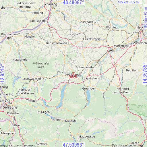
Dörfl GPS coordinates[2]
48° 0' 44.82" North, 13° 39' 16.992" East
| Map corner | latitude | longitude |
|---|---|---|
| Upper-left | 48.48067°, | 12.9516° |
| Center: | 48.01245°, | 13.65472° |
| Lower-right: | 47.53993°, | 14.35785° |
| Map W x H: | 104.6×104.6 km | = 65×65mi |
| max Lat: | 48.98333° ⇑33.1% North |
| Dörfl: | 48.01245° |
| min Lat: | ⇓66.9% South 46.48841° |
| min Long | Dörfl | max Long |
| 9.57802° | 13.65472° | 17.1° |
| W 27.7%⇐ | ⇒72.3% E |
Elevation
Elevation of Dörfl is 437 m = 1434 ft, and this is 68.5 m = 225 ft below average elevation for this country.
| Max E: |
2140 m = 7021 ft | 52.3% |
| Avg. | 505.5 m = 1658 ft | |
| Dörfl | 437 m = 1434 ft | |
Min E: |
118 m = 387 ft | 47.7% |
See also: Austria elevation on elevation.city.
Geographical zone
Dörfl is located in North temperate zone (between Tropic of Cancer and the Arctic Circle). Distance of this North polar circle is 2062.7 km =1281.7 mi to North.| Distance of | km | miles | from Dörfl |
|---|---|---|---|
| North Pole | 4668.6 | 2900.9 | to North |
| Arctic Circle | 2062.7 | 1281.7 | to North |
| Tropic Cancer | 2732.6 | 1698 | to South |
| Equator | 5338.5 | 3317.2 | to South |


Nearby cities:
15 places around Dörfl: (largest is in red/bold)
• Attnang
4.6 km =2.9 mi,  84°
84°
• Attnang-Puchheim
4.6 km =2.9 mi,  95°
95°
• Dürnau
1.9 km =1.2 mi,  203°
203°
• Lixlau
2 km =1.2 mi,  165°
165°
• Oberstraß
4.2 km =2.6 mi, 103°
• Pichlwang
3.6 km =2.2 mi,  232°
232°
• Preising
4.4 km =2.7 mi,  116°
116°
• Puchheim
4.8 km =3 mi,  106°
106°
• Regau
3.5 km =2.2 mi,  134°
134°
• Schalchham
2 km =1.2 mi,  141°
141°
• Schöndorf
1.2 km =0.7 mi, 165°
• Timelkam
3.6 km =2.2 mi,  254°
254°
• Ungenach
4.9 km =3 mi,  322°
322°
• Vöcklabruck
1.1 km =0.7 mi, 172°
• Wagrain
1.5 km =0.9 mi, 123°
Sources, notices
• [Note1] Compared only with cities in Austria existing in our database
• [Src1] Map data: © OpenStreetMap contributors (CC-BY-SA)
• [Src2] Other city data from geonames.org with taken over terms of usage.
• [Src3] Geographical zone / Annual Mean Temperature by Robert A. Rohde @ Wikipedia
