Mitterhausleiten geodata
Mitterhausleiten (Lower Austria) is a populated place; located in Austria in Europe/Vienna (GMT+2) time zone. With population of 671 people, there are 1926 cities with bigger population in this country. Compared to other cities in Austria, 71.2% of cities are located further ↓South; 50.1% of cities are located further →East and 69.4% of cities have higher elevation than Mitterhausleiten. Note1
Administrative division(s):
- Level 1: Lower Austria
- Level 2: Politischer Bezirk Amstetten
- Level 3: Aschbach-Markt


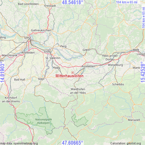
Mitterhausleiten GPS coordinates[2]
48° 4' 42.816" North, 14° 43' 19.74" East
| Map corner | latitude | longitude |
|---|---|---|
| Upper-left | 48.54618°, | 14.01903° |
| Center: | 48.07856°, | 14.72215° |
| Lower-right: | 47.60665°, | 15.42528° |
| Map W x H: | 104.5×104.5 km | = 64.9×64.9mi |
| max Lat: | 48.98333° ⇑28.8% North |
| Mitterhausleiten: | 48.07856° |
| min Lat: | ⇓71.2% South 46.48841° |
| min Long | Mitterhausleite | max Long |
| 9.57802° | 14.72215° | 17.1° |
| W 49.9%⇐ | ⇒50.1% E |
Elevation
Elevation of Mitterhausleiten is 331 m = 1086 ft, and this is 174.5 m = 573 ft below average elevation for this country.
| Max E: |
2140 m = 7021 ft | 69.4% |
| Avg. | 505.5 m = 1658 ft | |
| Mitterhausleiten | 331 m = 1086 ft | |
Min E: |
118 m = 387 ft | 30.6% |
See also: Austria elevation on elevation.city.
Geographical zone
Mitterhausleiten is located in North temperate zone (between Tropic of Cancer and the Arctic Circle). Distance of this North polar circle is 2055.3 km =1277.1 mi to North.| Distance of | km | miles | from Mitterhausleiten |
|---|---|---|---|
| North Pole | 4661.2 | 2896.3 | to North |
| Arctic Circle | 2055.3 | 1277.1 | to North |
| Tropic Cancer | 2739.9 | 1702.5 | to South |
| Equator | 5345.8 | 3321.7 | to South |


Nearby cities:
15 places around Mitterhausleiten: (largest is in red/bold)
• Allhartsberg
7.7 km =4.8 mi,  138°
138°
• Aschbach Markt
2.5 km =1.6 mi,  106°
106°
• Biberbach
5.5 km =3.4 mi,  191°
191°
• Hausmening
6.9 km =4.3 mi,  97°
97°
• Kematen an der Ybbs
6.7 km =4.2 mi,  151°
151°
• Mauer bei Amstetten
6.2 km =3.9 mi,  71°
71°
• Neufurth
6.7 km =4.2 mi,  89°
89°
• Oehling
6.3 km =3.9 mi, 67°
• Rosenau am Sonntagberg
8 km =5 mi,  170°
170°
• Sankt Johann in Engstetten
7.8 km =4.8 mi,  266°
266°
• Sankt Peter in der Au Dorf
6.6 km =4.1 mi,  245°
245°
• Sankt Peter in der Au Markt
8.4 km =5.2 mi,  242°
242°
• Seitenstetten Markt
7.4 km =4.6 mi,  226°
226°
• Ulmerfeld
7.2 km =4.5 mi, 91°
• Wolfsbach
4.3 km =2.7 mi, 252°
Sources, notices
• [Note1] Compared only with cities in Austria existing in our database
• [Src1] Map data: © OpenStreetMap contributors (CC-BY-SA)
• [Src2] Other city data from geonames.org with taken over terms of usage.
• [Src3] Geographical zone / Annual Mean Temperature by Robert A. Rohde @ Wikipedia
