Andritz geodata
Andritz (Styria) is a section of populated place; located in Austria in Europe/Vienna (GMT+2) time zone. With population of 19,020 people, there are 34 cities with bigger population in this country. Compared to other cities in Austria, 78.5% of cities are located further ↑North; 63.4% of cities are located further ←West and 62.7% of cities have higher elevation than Andritz. Note1


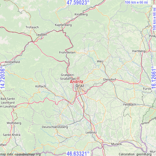
Andritz GPS coordinates[2]
47° 6' 49.932" North, 15° 25' 24.528" East
| Map corner | latitude | longitude |
|---|---|---|
| Upper-left | 47.59023°, | 14.72036° |
| Center: | 47.11387°, | 15.42348° |
| Lower-right: | 46.63321°, | 16.12661° |
| Map W x H: | 106.4×106.4 km | = 66.1×66.1mi |
| max Lat: | 48.98333° ⇑78.5% North |
| Andritz: | 47.11387° |
| min Lat: | ⇓21.5% South 46.48841° |
| min Long | Andritz | max Long |
| 9.57802° | 15.42348° | 17.1° |
| W 63.4%⇐ | ⇒36.6% E |
Elevation
Elevation of Andritz is 366 m = 1201 ft, and this is 139.5 m = 458 ft below average elevation for this country.
| Max E: |
2140 m = 7021 ft | 62.7% |
| Avg. | 505.5 m = 1658 ft | |
| Andritz | 366 m = 1201 ft | |
Min E: |
118 m = 387 ft | 37.3% |
See also: Austria elevation on elevation.city.
Geographical zone
Andritz is located in North temperate zone (between Tropic of Cancer and the Arctic Circle). Distance of this North polar circle is 2162.6 km =1343.8 mi to North.| Distance of | km | miles | from Andritz |
|---|---|---|---|
| North Pole | 4768.5 | 2963 | to North |
| Arctic Circle | 2162.6 | 1343.8 | to North |
| Tropic Cancer | 2632.7 | 1635.9 | to South |
| Equator | 5238.6 | 3255.1 | to South |


Nearby cities:
15 places around Andritz: (largest is in red/bold)
• Eggenberg
5.2 km =3.2 mi,  201°
201°
• Geidorf
3.7 km =2.3 mi,  154°
154°
• Graz
5.6 km =3.5 mi,  159°
159°
• Gries
5.7 km =3.5 mi,  179°
179°
• Gösting
2.6 km =1.6 mi,  227°
227°
• Hub
4.1 km =2.5 mi,  352°
352°
• Höf
5.6 km =3.5 mi,  66°
66°
• Innere Stadt
5.4 km =3.4 mi,  166°
166°
• Judendorf
5.6 km =3.5 mi,  273°
273°
• Lend
3.5 km =2.2 mi,  189°
189°
• Mariatrost
6 km =3.7 mi,  104°
104°
• Ries
5.8 km =3.6 mi,  126°
126°
• Sankt Leonhard
5.6 km =3.5 mi, 152°
• Stattegg
2.2 km =1.4 mi, 346°
• Ursprung
2.3 km =1.4 mi,  19°
19°
Sources, notices
• [Note1] Compared only with cities in Austria existing in our database
• [Src1] Map data: © OpenStreetMap contributors (CC-BY-SA)
• [Src2] Other city data from geonames.org with taken over terms of usage.
• [Src3] Geographical zone / Annual Mean Temperature by Robert A. Rohde @ Wikipedia
