Gösting geodata
Gösting (Styria) is a section of populated place; located in Austria in Europe/Vienna (GMT+2) time zone. With population of 11,255 people, there are 71 cities with bigger population in this country. Compared to other cities in Austria, 79.4% of cities are located further ↑North; 62.4% of cities are located further ←West and 61.2% of cities have higher elevation than Gösting. Note1


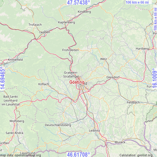
Gösting GPS coordinates[2]
47° 5' 52.368" North, 15° 23' 51.972" East
| Map corner | latitude | longitude |
|---|---|---|
| Upper-left | 47.57438°, | 14.69465° |
| Center: | 47.09788°, | 15.39777° |
| Lower-right: | 46.61708°, | 16.1009° |
| Map W x H: | 106.4×106.4 km | = 66.1×66.1mi |
| max Lat: | 48.98333° ⇑79.4% North |
| Gösting: | 47.09788° |
| min Lat: | ⇓20.6% South 46.48841° |
| min Long | Gösting | max Long |
| 9.57802° | 15.39777° | 17.1° |
| W 62.4%⇐ | ⇒37.6% E |
Elevation
Elevation of Gösting is 376 m = 1234 ft, and this is 129.5 m = 425 ft below average elevation for this country.
| Max E: |
2140 m = 7021 ft | 61.2% |
| Avg. | 505.5 m = 1658 ft | |
| Gösting | 376 m = 1234 ft | |
Min E: |
118 m = 387 ft | 38.8% |
See also: Austria elevation on elevation.city.
Geographical zone
Gösting is located in North temperate zone (between Tropic of Cancer and the Arctic Circle). Distance of this North polar circle is 2164.4 km =1344.9 mi to North.| Distance of | km | miles | from Gösting |
|---|---|---|---|
| North Pole | 4770.3 | 2964.1 | to North |
| Arctic Circle | 2164.4 | 1344.9 | to North |
| Tropic Cancer | 2630.9 | 1634.8 | to South |
| Equator | 5236.8 | 3254 | to South |


Nearby cities:
15 places around Gösting: (largest is in red/bold)
• Andritz
2.6 km =1.6 mi,  47°
47°
• Eggenberg
3.1 km =1.9 mi,  178°
178°
• Geidorf
3.8 km =2.4 mi,  113°
113°
• Gratkorn
5.3 km =3.3 mi,  317°
317°
• Graz
5.3 km =3.3 mi,  131°
131°
• Gries
4.4 km =2.7 mi,  153°
153°
• Innere Stadt
4.8 km =3 mi,  137°
137°
• Judendorf
4.2 km =2.6 mi,  300°
300°
• Kirchenviertel
5.3 km =3.3 mi,  314°
314°
• Lend
2.2 km =1.4 mi, 141°
• Stattegg
4.2 km =2.6 mi,  19°
19°
• Strassengel
5.3 km =3.3 mi,  292°
292°
• Thal
3.7 km =2.3 mi,  229°
229°
• Ursprung
4.8 km =3 mi,  34°
34°
• Wetzelsdorf
5 km =3.1 mi, 178°
Sources, notices
• [Note1] Compared only with cities in Austria existing in our database
• [Src1] Map data: © OpenStreetMap contributors (CC-BY-SA)
• [Src2] Other city data from geonames.org with taken over terms of usage.
• [Src3] Geographical zone / Annual Mean Temperature by Robert A. Rohde @ Wikipedia
