Vals geodata
Vals (Tyrol) is a seat of a third-order administrative division; located in Austria in Europe/Vienna (GMT+2) time zone. With population of 532 people, there are 2388 cities with bigger population in this country. Compared to other cities in Austria, 82.3% of cities are located further ↑North; 91.2% of cities are located further →East and 99.2% of cities have lower elevation than Vals. Note1


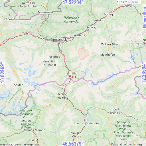
Vals GPS coordinates[2]
47° 2' 42.252" North, 11° 31' 58.116" East
| Map corner | latitude | longitude |
|---|---|---|
| Upper-left | 47.52204°, | 10.82969° |
| Center: | 47.04507°, | 11.53281° |
| Lower-right: | 46.56379°, | 12.23594° |
| Map W x H: | 106.5×106.5 km | = 66.2×66.2mi |
| max Lat: | 48.98333° ⇑82.3% North |
| Vals: | 47.04507° |
| min Lat: | ⇓17.7% South 46.48841° |
| min Long | Vals | max Long |
| 9.57802° | 11.53281° | 17.1° |
| W 8.8%⇐ | ⇒91.2% E |
Elevation
Elevation of Vals is 1352 m = 4436 ft, and this is 846.5 m = 2777 ft above average elevation for this country.
| Max E: |
2140 m = 7021 ft | 0.8% |
| Vals | 1352 m 4436 ft | |
| Avg. | 505.5 m = 1658 ft | |
Min E: |
118 m = 387 ft | 99.2% |
See also: Austria elevation on elevation.city.
Geographical zone
Vals is located in North temperate zone (between Tropic of Cancer and the Arctic Circle). Distance of this North polar circle is 2170.3 km =1348.6 mi to North.| Distance of | km | miles | from Vals |
|---|---|---|---|
| North Pole | 4776.1 | 2967.7 | to North |
| Arctic Circle | 2170.3 | 1348.6 | to North |
| Tropic Cancer | 2625 | 1631.1 | to South |
| Equator | 5230.9 | 3250.3 | to South |


Nearby cities:
15 places around Vals: (largest is in red/bold)
• Ausserweg
10.5 km =6.5 mi,  339°
339°
• Außerschmirn
4.3 km =2.7 mi,  0°
0°
• Gries am Brenner
4 km =2.5 mi,  259°
259°
• Gschnitz
13.8 km =8.6 mi,  269°
269°
• Matrei am Brenner
11.1 km =6.9 mi,  326°
326°
• Mauern
7.9 km =4.9 mi,  320°
320°
• Mühlbachl
11.6 km =7.2 mi, 327°
• Obernberg am Brenner
9.4 km =5.8 mi,  250°
250°
• Oberweg
9.9 km =6.2 mi,  352°
352°
• Pfons
12.1 km =7.5 mi, 333°
• Schmirn
5 km =3.1 mi,  31°
31°
• Schöfens
11.4 km =7.1 mi, 330°
• Statz
10.1 km =6.3 mi, 321°
• Steinach am Brenner
6.6 km =4.1 mi,  310°
310°
• Trins
9.8 km =6.1 mi,  295°
295°
Sources, notices
• [Note1] Compared only with cities in Austria existing in our database
• [Src1] Map data: © OpenStreetMap contributors (CC-BY-SA)
• [Src2] Other city data from geonames.org with taken over terms of usage.
• [Src3] Geographical zone / Annual Mean Temperature by Robert A. Rohde @ Wikipedia
